Arizona State Route 85
The highway runs from the United States–Mexico border near Lukeville to the north ending at Interstate 10 (I-10) in Buckeye.
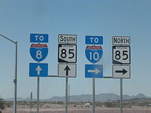
The highway also intersects I-8 in Gila Bend and serves as a connector between I-8 and I-10 and for travelers between Phoenix and Yuma as well as San Diego.
The southern terminus of SR 85 is located at the Mexican border near Lukeville in Pima County.
SR 85 heads north from the border as a two-lane road, passing through the Organ Pipe Cactus National Monument.
[5] The highway passes near the western edge of the Sonoran Desert National Monument and also provides access to the Buckeye Hills Regional Park.
The highway intersects Buckeye Road which is where the original routing of US 80 and later SR 85 followed into Phoenix before being rerouted onto its current alignment.
The highway continues towards the north, crossing over the Buckeye Canal before reaching its northern terminus at exit 112 on I-10.
[7] A dirt road between Gila Bend and Ajo did exist at this time, but it was not a part of the state highway system.
[21] In 2010, an environmental study into building a freeway-to-freeway interchange in Gila Bend from SR 85 to I-8 was completed by ADOT and the Federal Highway Administration.
The study found no significant impact on the local environment and outlined a finalized full freeway standard design, bypassing the I-8 Business/Maricopa Road intersection SR 85 currently traverses through.
Maricopa County Route 85 (MC 85) is an unsigned 26-mile (42 km) long road that runs along former SR 85 from Buckeye to Tolleson.