Arlington, Washington
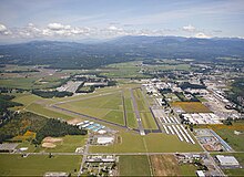
During the Great Depression of the 1930s, the Arlington area was the site of major projects undertaken for employment under the direction of federal relief agencies, including construction of a municipal airport that would serve as a naval air station during World War II.
The indigenous Coast Salish peoples have inhabited the Puget Sound region since the retreat of the Vashon Glacier approximately 12,000 years ago.
[5][11]: 2 The area was opened to logging after the signing of the Treaty of Point Elliott in 1855 between the federal government and various Puget Sound peoples.
[12] The Stillaguamish, one of the signatory tribes, were ordered to travel to the Tulalip Indian Reservation, but many members refused and remained in their ancestral lands.
[8] In the 1880s, wagon roads were constructed to this area from the towns of Marysville to the south and Silvana to the west, bringing entrepreneurs to the logging camps, informally named "The Forks".
[13][14] Two settlements were established on the south side of the confluence in anticipation of the Seattle, Lake Shore and Eastern Railway building a track through the area.
[5][13]: 804–806 Arlington and Haller City grew rapidly in their first years, reaching a combined population of 500 by 1893, relying on agriculture, dairy farming and the manufacturing of wood shingles as their main sources of income.
[5][14] Both towns established their own schools, post offices, saloons, general stores, churches, social clubs, and hotels.
[17] During the late 1890s, the claim dispute was settled and merchants began moving to the larger, more prosperous Arlington, signalling the end for Haller City.
[11]: 16 [13][23] In the years following incorporation, Arlington gained a local bank, a cooperative creamery, a city park, a library, electricity, and telephone service.
Other industries, including dairy processing, mechanical shops, stores, and factories, became prominent after World War I, during a period of growth for the city.
The federal government established a Civilian Conservation Corps (CCC) camp near Darrington to create temporary jobs; the young men built structures and conducted firefighting in the Mount Baker National Forest.
[5] The entry of the United States into World War II brought the U.S. Navy to Arlington, resulting in the conversion of the municipal airport into a naval air station in 1943.
The plane, being flown by Boeing test pilots instructing personnel from Braniff International Airways, lost three engines and suffered a fire in the fourth after a dutch roll had been executed beyond maximum bank restrictions.
[25][26][27] The completion of Interstate 5 and State Route 9 in the late 1960s brought increased residential development in Arlington, forming a bedroom community for commuters who worked in Everett and Seattle.
[38] The project was credited with helping revitalize the city's downtown, turning Olympic Avenue into a gathering place for residents and a venue for festivals.
[39] On March 22, 2014, a large landslide near Oso dammed the North Fork of the Stillaguamish River, with mud and debris covering an area of one square mile (2.6 km2).
[40][41] The landslide closed State Route 530 to Darrington, cutting the town off, leaving Arlington as the center of the coordinated emergency response to the disaster.
[42] Arlington was recognized for its role in aiding victims of the disaster and hosted U.S. President Barack Obama during his visit to the site in April.
[43][44] The city has continued to grow in the late 2010s, with new apartment buildings constructed in Smokey Point, including those designed as retirement communities.
[55][56] The Stillaguamish River valley and floodplain, including Arlington, lies in a lahar hazard zone 60 miles (97 km) downstream from Glacier Peak, an active stratovolcano in the eastern part of the county.
[52]: 4–10 [63] Arlington has a general climate similar to most of the Puget Sound lowlands, with dry summers and mild, rainy winters moderated by a marine influence from the Pacific Ocean.
[81] Arlington's early economy relied heavily on timber harvesting and processing, notably the production of red cedar wood shingles at mills that closed during the Great Depression of the 1930s.
[99] According to the Washington State Auditor, Arlington's municipal government employs 128 people full-time and operates on an annual budget of $50 million.
[100] The municipal government provides emergency services, as well as water and sewage utilities, street maintenance, parks and recreation, an airport, and a cemetery.
[119] Arlington has 17 city-maintained parks with over 257 acres (104 ha) of public open space within its city limits and urban growth boundary.
[15] It has been under common ownership with the Marysville Globe since 1964;[138] Sound Publishing, which acquired both papers in 2007, suspended their publication in March 2020 in the wake of the COVID-19 pandemic.
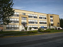
[153] The museum overlooks the Stillaguamish River and features preserved household items, logging equipment, and vehicles, historic newspapers and images from the Arlington area, and a model railroad.
[171] In 1966, the Smokey Point area was proposed as the location of a four-year public college, with 645 acres (261 ha) offered by the city of Arlington to the state government.
[194][195] Arlington is served by three telephone companies and internet service providers: Comcast (Xfinity), Frontier Communications (including Verizon FiOS), and Wave Broadband.