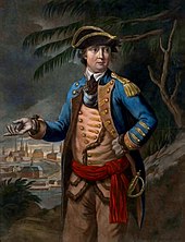
Benedict Arnold's expedition to Quebec
In September 1775, early in the American Revolutionary War, Colonel Benedict Arnold led a force of 1,100 Continental Army troops on an expedition from Cambridge in the Province of Massachusetts Bay to the gates of Quebec City.
The areas on either side of the height of land were swampy tangles of lakes and streams, and the traversal was made more difficult by bad weather and inaccurate maps.
Arnold's troops crossed the Saint Lawrence on November 13 and 14, assisted by the local French-speaking Canadiens, and attempted to put Quebec City under siege.
On May 10, 1775, shortly after the American Revolutionary War began, Benedict Arnold and Ethan Allen led an expedition that captured Fort Ticonderoga on Lake Champlain in the British Province of New York.
He went to Cambridge, Massachusetts in early August, and approached George Washington, Commander-in-Chief of the Continental Army, with the idea of a second eastern invasion force aimed at Quebec City.
[7] Washington approved of the idea in principle, but sent a message to General Schuyler on August 20 to ensure his support of the endeavor, since the two forces would need to coordinate their efforts.
[8] Arnold's plan called for the expedition to sail from Newburyport, Massachusetts along the coast and then up the Kennebec River to Fort Western (now Augusta, Maine).
Colburn offered his services, and Arnold requested detailed information about the route, including potential British naval threats, Indian sentiment, useful supply opportunities, and an estimate of how long it would take to construct bateaux sufficient for the contemplated force.
Schuyler agreed with the suggested plan, and Washington and Arnold immediately began to raise troops and place orders for supplies.
[21] On September 2, as soon as General Schuyler's agreement with the expedition was known, Arnold wrote a letter to Nathaniel Tracy, a merchant of his acquaintance in Newburyport.
The sea voyage was viewed by both Arnold and Washington as the most dangerous part of the expedition, because British patrols were highly effective at interfering with colonial shipping at the time.
The first units to leave were composed largely of men from that area, to whom Arnold had given extra time so that they would be able to see their families once more before the expedition left Newburyport.
[23] Arriving in Gardinerston on the 22nd, they spent the next few days at Reuben Colburn's house, organizing supplies and preparing the boats they would use for the rest of the expedition.
[24] Arnold inspected Colburn's hastily constructed bateaux, finding them, in a portent of troubles to come, to be "very badly built", and "smaller than the directions given".
General Thomas Gage in Boston was aware that Arnold's troops were "gone to Canada and by way of Newburyport", but he believed the target to be Nova Scotia, which was at the time virtually undefended.
[26] Francis Legge, the governor of Nova Scotia declared martial law, and on October 17 sent a message to England laden with rumors about American actions that turned out to be false.
Admiral Samuel Graves eventually received intelligence about Arnold's activities, reporting on October 18 that the American troops "went up the Kennebec River, and 'tis generally believed are for Quebec".
The source of these rumors was Natanis, a Norridgewock Indian believed to be spying for Quebec's governor, General Guy Carleton; Arnold discounted the reports.
[33] The portage around Norridgewock Falls, a distance of about one mile (1.6 km), was accomplished with the assistance of oxen provided by the local settlers, but it took almost a week to complete; Arnold did not depart from there until October 9.
[35] The Great Carrying Place was a portage of roughly 12 miles (19 km), bypassing an unnavigable section of the Dead River, the tributary of the Kennebec that the expedition was to follow.
[36] Lieutenant Church, the leader of the survey team, described the route as a "bad road but capable of being made good", an assessment that turned out to be somewhat optimistic.
[37] The vanguard of the main body, led by Daniel Morgan, met Lieutenant Steele's scouting party en route to the first pond.
Early on October 22, the men awoke to discover that the river had risen to the level of their camp, and they had to scramble to even higher ground for safety.
The officers agreed, and decided to pick an advance party that would proceed as rapidly as possible to French settlements on the Chaudière, and work to bring supplies back.
[49] As a result, some elements of the expedition spent two days lost in swamps before the majority finally reached the falls on the upper Chaudière on October 31.
Jacques Parent, a Canadien from Pointe-Levi, notified Arnold that Lieutenant Governor Cramahé had ordered the destruction of all boats on the southern banks of the Saint Lawrence after receiving the intercepted communications.
Some of Arnold's men purchased canoes from the habitants and the local Saint Francis Indians, and then transported them from the Chaudière to the mill site.
[57] The city of Quebec was then defended by about 150 men of the Royal Highland Emigrants under Lieutenant Colonel Allen Maclean, supported by about 500 poorly organized local militia and 400 marines from the two warships.
After hearing rumors of a planned sortie from the city, Arnold decided on November 19 to withdraw to Pointe-aux-Trembles to wait for Montgomery, who had recently captured Montreal.
Arnold, who commanded the army's rear guard in the later stages of the retreat, was able to delay the British advance sufficiently to prevent them from attempting to reach the Hudson River in 1776.

*A: Cambridge
*B: Newburyport
*C: Fort Western
*D: Fort Halifax
*E: Great Carrying Place
*F: Height of land
*G: Lake Mégantic
This map does not accurately represent the area around the height of land and Lake Mégantic.