Athabasca Valles
[2] The materials forming the valley floor of the system are thought to be ultramafic or mafic in composition, characterized by an abundance of Fe and a relative dearth of K and Th based on data from the Gamma Ray Spectrometer (GRS).
[14] The Athabasca Valles are located within the broader Elysium Planitia region and cross-cuts a vast swath of plains land interpreted to be composed largely of flood basalts.
Historically, some researchers have associated the outpouring of fluid from the Athabasca Valles with the downstream formations of Marte Vallis and the Grjotá Valles, but this perspective fell out of favor as higher-resolution MOC data became available, allowing updated crater counts (the age dates of each valley floor are asynchronous) and geomorphic interpretations (high-permeability fresh lava rock would have caused large-scale infiltration of errant floodwaters long before reaching the other valleys' heads).
[17][18][15] Because evidence of fluvial erosion is present on both sides of the fissure, some authors have proposed that the outflow of floodwater from Cerberus Fossae was violent, forming a fountain akin to Old Faithful in Yellowstone National Park, which is a geyser in the U.S. state of Wyoming.
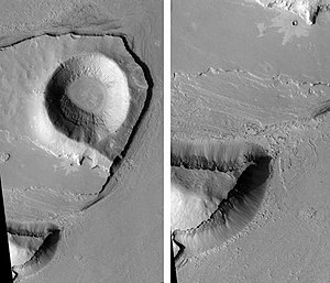
[8] Some researchers have proposed that the formation of the streamlined forms in the Athabasca Valles may have been a result of bedrock obstacles (such as crater rims) persisting in areas of low elevation, where hydrological modeling suggests floodwaters might have ponded.
[19] In support of the megaflooding hypothesis, some authors have interpreted the platy and ridged terrains (described by others as characteristic lava textures) as relict sections of the underlying Medusae Fossae Formation that have been exhumed by aeolian processes.
Based on hydrological modeling, some authors have noted that there are no other water-based mechanisms, including gravitationally-controlled groundwater flow or the magmatic melting of ground ice, which could explain the volume of water required to carve the Athabasca Valles.
Any rupturing and faulting associated with this tectonic activity would penetrate the overlying cryosphere (in a dry and cold Amazonian Mars); to compensate for its pressurization, reservoir fluids would be forced upwards through the fissure, forming the outflow channel morphologies observed on the surface.
[15] This interpretation has been disputed, with counterclaims that the diking or extensional fracturing that formed Cerberus Fossae would have had to uniformly breach the entirety the thick protective cryosphere in order to allow groundwater to escape in sufficient quantities to hydrodynamically satisfy the Athabasca Valles' megaflood formation scenario.
Although ice rafts can manifest as plates of a similar size, shape, and distribution, there are no known glacial mechanisms that can create the coiled morphologies observed downstream of the Athabasca Valles.
[2] Some authors have proposed that a combination of mechanisms can satisfactorily explain the origin of the Athabasca Valles system – namely, the large-scale emplacement of low-viscosity lava flows on top of pre-existing glaciers.
Individual periods of volcanic activity constituting the modern Elysium Planitia region are thought to have lasted up to 1 Myr, with the rock in the vicinity of the Athabasca Valles being potentially deposited on a timescale of weeks or months.
As seen on THEMIS data, these morphologies are consistent in size and shape with different stages of the pingo lifecycle observed on Earth in the Russian federal subject of Yakutia and the Tuktoyaktuk Peninsula in the Canadian Northwest Territories.
Sudden exposure of the melting permafrost to freezing conditions triggers the uplift as the water content of the saturated ground expands (leading to the formation of the observed circular mounds).
[26] In 2003, Devon M. Burr published her doctoral dissertation, undertaken under her advisor Victor R. Baker at the University of Arizona, characterizing the outflow channels of Elysium Planitia, including the Athabasca Valles.
[8] In 2003, Stephanie C. Werner and Gerhard Neukum of the Free University of Berlin and Stephan van Gasselt of the German Aerospace Center (DLR) re-affirmed the earlier crater-age dates asserted in 2001 by Berman and Hartmann using MGS data (MOC and MOLA).
The researchers asserted that the valley is older than previously believed, noting the presence of flood deposits past the Athabasca Valles' debouchment dating back to as early as 1.6 Ga.
In his dissertation, among other topics, he invented a novel point photoclinometry method used to assess the surface roughness in the ellipses of candidate landing sites of NASA's Mars Exploration Rovers (Spirit and Opportunity).
This constraint was partially made based on the authors' assertion that Zunil is a strong candidate source for the shergottite meteorites, which are basalts of Martian origin that have been found and analyzed on Earth.
[28] In 2007, Windy L. Jaeger, Lazlo P. Keszthelyi, Alfred McEwen, Patrick S. Russell and Colin S. Dundas (University of Arizona) examined very high resolution images from HiRISE and reassessed earlier interpretations of the Athabasca Valles system in light of the new available data.
They re-interpreted all putative glacial features observed both in the Athabasca Valles and downstream in Cerberus Palus as volcanic in nature, directly challenging the periglacial hypothesis claimed by David Page and co-workers.
[1] David Page directly disputed the authors' volcanic interpretations of the pitted mounds and polygonal terrains in a later publication, noting that these features occasionally are found to superpose impact craters.
Jaeger and her co-workers also noted GRS, SHARAD and CRISM interpretations strongly suggesting that water ice has not been a major reshaping force in the geologic history of the Athabasca Valles.
[6] In 2009, Joyce Vetterlein and Gerald P. Roberts of the University of London in England reported on the presence of extensional faulting off southern Cerberus Fossae, cross-cutting morphologies attributed to both the outflow channel and to subsequent lava cover.
This subsidence was decisively attributed to faulting and not to a local collapse in the cryosphere; the authors noted, then, that the topography of the Cerberus Fossae alone cannot be used to infer the volume of the fluid that carved the Athabasca Valles.
[14] Researchers from the United States Geologic Survey (including Windy Jaeger, Lazlo Keszthelyi, and James A. Skinner) and Alfred McEwen (University of Arizona) published a study in 2010 using high-resolution HiRISE and CTX data to map flood lavas in the Athabasca Valles region.
[29] In 2012, Andrew J. Ryan and Phil Christensen (of Arizona State University) observed the presence of lava coil-like structures on fractured plates immediately downstream of the Athabasca Valles.
[20] In 2015, Rina Noguchi and Kei Kurita of the University of Tokyo attempted to reconcile the ongoing disagreements over the origin of the ring-mound landforms by evaluating the spatial distributions and unique morphologies of the different types of RMLs present in the valley.
[5] Also in 2018, a collaboration of Italian, German and French researchers including Barbara de Toffoli developed and validated a fractal analysis tool designed to correspond Martian mound-like structures to associated regional fracture zones in order to predict the extent of their source reservoirs.
Among the features chosen for analysis, the researchers examined putative pingoes in the Athabasca Valles on HiRISE data, which were compared to terrestrial analogues in the Russian Kolyma Lowland region.