Athy
Athy (/əˈθaɪ/ ə-THY;[2] Irish: Baile Átha Í, meaning '[town of the] ford of Ae'[3]) is a market town at the meeting of the River Barrow and the Grand Canal in south-west County Kildare, Ireland, 72 kilometres southwest of Dublin.
[4][3] The Letters of the Ordnance Survey (1837) note that "The town is now called by the few old people who speak Irish there and in the Queen's County [Laois], "baile átha Aoi", pronounced Blahéé", where éé stands for English 'ee' [i:] as clarified by a note written in pencil in Irish as Blá thí.
[5] According to Elizabethan historian William Camden, Ptolemy's map of Ireland circa 150 AD names the Rheban district along the River Barrow as Ῥαίβα.
[10] The completion of the Grand Canal in 1791, linking here with the River Barrow, and the arrival of the railway in 1846, illustrate the importance of the town as a commercial centre.
Positioned at the edge of the Pale, sandwiched between the Irish and English speaking partitions, Athy traded language between the landed gentry, the middle class merchants, the English working class garrison soldiers and the local peasantry.
This tradition of spoken word led to a lyrical approach to composition and perhaps explains the disproportionate number of writers Athy has produced.
Athy becomes subject and object of creative endeavours – the traditional folk song, "Johnny I Hardly Knew Ye", is a prime example.
[12] Athy is also the surname of a minor character in James Joyce's Portrait of the Artist as a Young Man, who tells Stephen Dedalus, the protagonist, that they both have strange surnames and makes a joke about County Kildare being like a pair of breeches because it has Athy in it.
Patrick Kavanagh alludes to Athy in his poem Lines Written on a Seat on the Grand Canal, Dublin: "And look!
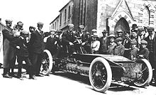
After some lobbying and changes to local laws, County Kildare was chosen, partly because the straightness of the roads would be a safety benefit.
In 2010 the N78 was re-aligned so that it no longer heads from Athy towards Kilcullen and Dublin via Ardscull, but now connects with the M9 motorway near Mullamast.
This side line was built by the United Kingdom government in 1918 due to wartime shortage of coal in Ireland.
South Kildare Community Transport also operates two routes from the town serving outlying villages and rural areas.
In 1905 the club rented a field at the Dublin road from the South Kildare Agricultural Society—the present day Geraldine Park.