Atmospheric instability
[clarification needed][1] Atmospheric instability encourages vertical motion, which is directly correlated to different types of weather systems and their severity.
In meteorology, instability can be described by various indices such as the Bulk Richardson Number, lifted index, K-index, convective available potential energy (CAPE), the Showalter, and the Vertical totals.
Stable atmospheres can be associated with drizzle, fog, increased air pollution, a lack of turbulence, and undular bore formation.
CAPE is effectively the positive buoyancy of an air parcel and is an indicator of atmospheric instability, which makes it valuable in predicting severe weather.
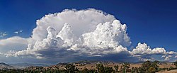
This usually creates vertically developed clouds from convection, due to the rising motion, which can eventually lead to thunderstorms.
[7] The application of the Showalter index is especially helpful when there is a cool, shallow air mass below 850 hPa that conceals the potential convective lifting.
[10] Conditions associated with a marine layer, a stable atmosphere common on the west side of continents near cold water currents, leads to overnight and morning fog.
The approaching boundary will create a disturbance in the atmosphere producing a wave-like motion, known as a gravity wave.
However, because of gravity, the water or medium is pulled back down and the repetition of this cycle creates the transverse wave motion.
Over warm ocean waters and within a region of the troposphere with light vertical wind shear and significant low level spin (or vorticity), such thunderstorm activity can grow in coverage and develop into a tropical cyclone.
[14] When winds are light, dust devils can develop on dry days within a region of instability at ground level.
[15] Small-scale, tornado-like circulations can occur over or near any intense surface heat source, which would have significant instability in its vicinity.