Auburn Dam
However, some groups continue to support construction of the dam, which they state would provide important water regulation and flood protection.
These early flood control works were insufficient; in 1862, the city was inundated so completely that the state government was temporarily moved to San Francisco.
[3] In 1955, the U.S. Army Corps of Engineers built the Folsom Dam at the confluence of the North and South Forks of the American River to provide flood control for the Sacramento metropolitan area.
Irrigation with dam and canal systems was favored because the seasonal nature of the American River caused floods in some years and droughts in others.
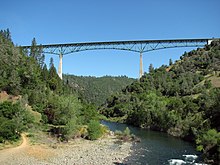
Even before the project was authorized, contracts were let for the construction of a high bridge to carry the road over the proposed reservoir, as well as preliminary excavations at the dam site.
[2] Official groundbreaking of the Auburn Dam started on October 19, 1968, with preparatory excavations and test shafts drilled into the sides of the North Fork American River gorge.
[14] It also improved safety and reduced travel time by eliminating a steep, narrow and winding grade into the canyon on either side of the river, as comparisons to maps showing the old road alignment will attest.
[15] This quake concerned geologists and engineers working on the project so much that the Auburn Dam construction was halted while the site was resurveyed and investigations conducted into the origins of the earthquake.
[11] In early February 1986 ten inches (254 mm) of rain fell on the Sacramento region in 11 days, melting the Sierra Nevada snowpack and causing a huge flood to pour down the American River.
Folsom Lake filled to dangerously high levels with runoff from the North, Middle and South Forks of the American River.
[20] The flood rapidly filled the pool behind the Auburn cofferdam to capacity, as the diversion tunnel could not handle all the water pouring into the reservoir.
Although the cofferdam was designed with a soft earthen plug to fail in a controlled manner if any such event were to occur,[21] the structure eroded quicker than expected.
The proposed Auburn Reservoir, with a mere 8% of that capacity, would require the construction of a dam as tall as Hoover and over three times as wide.
Also, the United States National Research Council believes that existing stream-flow records, which only date back about 150 years, are insuffient to justify the construction of a dam as large as Auburn.
[28] A Bureau of Reclamation study released in 1980 projected that a failure of Auburn Dam would result in a giant wave reaching Folsom Lake within five minutes; depending on reservoir levels, it would cause a cascading failure of Folsom and Nimbus Dams downstream within an hour, unleashing millions of acre-feet of water which would cause far greater damage downstream than any natural flood.
[15] If Auburn were to fail at full capacity, the resulting flood would be over three times larger, and cause even greater damage, inundating land for miles on either side of the American and Sacramento rivers.
[29] Filling the Auburn Reservoir would result in a two-pronged, 40-mile (64 km) lake which would inundate numerous canyons and rapids of the North and Middle Forks of the American River.
[19] Over one million people visit the canyons of the North and Middle Forks of the American River each year to engage in various recreational activities, including kayaking, rafting, hiking, hunting, biking, horseback riding, gold mining, off-roading, and rock climbing.
[31] The Auburn Reservoir would also result in the destruction of thousands of acres of riverine habitat,[31] and the inundation of historic and archaeological sites.
[33] Representative Norman D. Shumway introduced the Auburn Dam Revival Act of 1987, which was rejected because of the phenomenally high costs.
[36] As the years dragged on, the cost of the project grew, and it officially ended with the revoking of USBR water rights to the site by the state on November 11, 2008.
[32] Auburn Dam is the public works equivalent of a Hollywood zombie, rivaling any Tinseltown creation in its ability to withstand repeated attempts to kill it.
First proposed nearly a half-century ago for a site in the American River canyon near the Gold Rush town of Auburn, the dam has withstood attacks by U.S. presidents, member of Congress, state and federal agencies, environmentalists, tax watchdogs, scientists, engineers and even nature itself—the political equivalent of being shot, stabbed, drowned, poisoned, electrocuted and set on fire.
[43] Also, with the construction of a "dry" Auburn Dam, Folsom Lake could be kept at a higher level throughout the year because of reduced flood-control pressure, therefore facilitating recreational access to the reservoir.
Finally, regulations in flow could help groundwater recharge efforts; the lower Sacramento Valley aquifer is acknowledged as severely depleted.
[12] As of now, massive evidence of the dam's construction still remain in the North Fork American River canyon, specifically the excavations for the abutments and spillway, with the consequences of increased erosion.
One, the Peripheral Canal, would facilitate water flow from the water-rich north to the dry south, but has never been built due to environmental concerns.
Additional work proposed includes a possible raise of Folsom Dam several feet to improve its flood control and storage capacity.
Sugar Pine Reservoir, an auxiliary component of the Auburn-Folsom South Project upstream in the watershed, was transferred in title by the Bureau of Reclamation to Foresthill Public Utility District in 2003.
The river diversion tunnel was sealed but not filled in, and the remnants of the construction site in the riverbed as well as the remains of the cofferdam excavated from the canyon.