Sacramento River
Historically, its watershed has reached as far north as south-central Oregon where the now, primarily, endorheic (closed) Goose Lake rarely experiences southerly outflow into the Pit River, the most northerly tributary of the Sacramento.
The Sacramento and its wide natural floodplain were once abundant in fish and other aquatic creatures, notably one of the southernmost large runs of chinook salmon in North America.
While it is now providing water to over half of California's population and supporting the most productive agricultural area in the nation, these changes have left the Sacramento greatly modified from its natural state and have caused the decline of its once-abundant fisheries.
Saltwater intrusion from the Pacific Ocean was one of the main reasons for the construction of the federal Central Valley Project (CVP), whose dams maintain a minimum flow in the Sacramento River to keep seawater at bay.
[3] Flow in the Yolo Bypass, a relief channel designed to carry a portion of the flood waters in order to protect the Sacramento area, is not measured by the Freeport gauge.
The Colorado River, which reaches the Gulf of California just south of the US-Mexico border near the southeast part of the state, is far larger than the Sacramento in terms of length and drainage area but has a slightly smaller flow.
[28][29] The basin's diverse geography ranges from the glacier-carved, snowcapped peaks of the Sierra Nevada to the sea-level (and often lower) marshes and farmlands of the Sacramento-San Joaquin Delta.
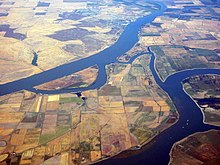
The river flows at an elevation somewhat higher than the surrounding terrain due to deposits of sediment over millennia that created raised banks (essentially natural levees).
The banks separate the river from the lowlands to the east and west that once served as vast overflow basins during winter storms, creating large areas of seasonal wetlands.
By the early 20th century engineers had realized not all the floodplains could be safely reclaimed, leading to the intentional creation of flood bypasses where development is limited to annual crops and recreational uses.
It also extends into portions of Siskiyou, Modoc, Lassen, Lake (in Oregon), Sierra, Nevada, Placer, El Dorado, Sacramento, Solano and Contra Costa Counties.
The river itself flows through Siskiyou, Shasta, Tehama, Butte, Glenn, Colusa, Sutter, Yolo, Sacramento, Solano and Contra Costa, often forming boundaries between the counties.
[35] As the Sierra rose, water erosion and glaciation carved deep canyons, depositing massive amounts of sediment to form a coastal plain between the mountains and the Pacific Ocean.
About 650,000 years ago the lake catastrophically overflowed, draining into San Francisco Bay and creating the Carquinez Strait, the only major break for hundreds of miles in the Coast Ranges.
These are known as the Shasta, Modoc, and Achomawi/Pit River Tribes of the volcanic plateaus in the north; the Wintu and Hupa in the northern Klamath and Trinity mountains; the Nomlaki, Yuki, Patwin, and Pomo of the Coast Ranges; the Yana, Atsugewi, Maidu, Konkow, and Nisenan in the Sierra and their western foothills; and the Miwok in the south.
The river also provided shellfish, sturgeon, eel and suckerfish They also hunted waterfowl, antelope and deer which all existed in huge numbers in the rich valley bottom and marsh lands.
In the years to come, this path, which eventually extended from San Francisco to Portland, Oregon following parts of the Sacramento, Willamette, Klamath, Rogue, and other rivers would become an important trade and travel route.
Naming it New Helvetia, he created an agricultural empire in the lower Sacramento Valley, attracting several hundred settlers to the area, and relied on Native American labor to maintain his domain.
[54] Although Sutter and Marshall originally intended to keep the find a secret, news soon broke attracting three hundred thousand hopefuls from all over North America, and even the world, to the Sacramento River in search of fortunes, kicking off the California Gold Rush.
[56] As the miners expanded their diggings deeper into the Sierra Nevada and Klamath Mountains, Native Americans were pushed off their land and a long series of skirmishes and fights began that continued until intervention by the state and national governments.
[63] The city of Sacramento, founded on the original site of Sutter's fort, began to flourish as the center of an agricultural empire that provided food to feed the thousands of miners working in the hills as well as a place of financial exchange of all the gold that was mined.
[64] As the economy of the Sacramento Valley grew, the Southern Pacific Railroad established tracks along the river to connect California with Oregon following the ancient path of the Siskiyou Trail, in the 1880s and 1890s.
Starting at the Red Bluff Diversion Dam on the Sacramento, the canals are 111 and 21 mi (179 and 34 km) long respectively, and divert a total of over 3,000 cubic feet per second (85 m3/s) of water to irrigate some 150,000 acres (610 km2).
[80] From its origin at the Delta the canal runs 444 miles (715 km) southwards through the west side of the San Joaquin Valley, providing irrigation water to farmlands along its length, and lifted almost 3,000 feet (910 m) over the Tehachapi Mountains via four large pumping stations.
Amphibians originally thrived in the marshes, sloughs, side-channels and oxbow lakes because of their warmer water, abundance of vegetation and nutrients, lower predator populations and slower current.
UC Davis also concluded from past experimental releases of salmon, that the Yolo Bypass floodway could have up to 57,000 acres of a productive breeding habitat with almost no cost to farmers.
The Nigiri project attempted to see if these floodplains as surrogate wetlands which can be controlled to copy the Sacramento River system's annual natural flooding cycle the native fish depend on.
[101][102] By the late 20th and early 21st centuries, the government blamed crashing fish populations on overfishing, especially off the Northern California and Oregon coast, which lie directly adjacent to the migration paths of Sacramento River salmon.
Increased erosion caused by the removal of riparian vegetation and the runoff of fertilizers into the river have led to occasional algae blooms, though the water is usually cold because of the regulation of dams upstream.
According to the USGS 2016, the mercury release leaves a permanent imprint not only in the Sacramento River Watershed but also in peat bogs, snowcapped glaciers and sediments up to hundreds and thousands of miles away.