August Complex fire
Rugged terrain combined with consistent high winds and record heat had complicated firefighting efforts.
[1] The U.S. Forest Service managed the firefighting effort, with assistance from the California Department of Forestry and Fire Protection.
Due to the immense size of the affected area, the fire was managed as four separate incidents (initially three) within a larger complex.
[7] On the early morning of August 17, thunderstorms carried northward from the weakening Tropical Storm Fausto moved across Glenn and Mendocino Counties, starting at least 13 fires.
By 5:00 pm PDT, the Doe Fire in Glenn County 35 miles (56 km) north of Willows had grown to 100 acres (40 ha), and firefighters had arrived on the scene.
[16] On August 21, due to continued high fire danger, the Mendocino National Forest was temporarily closed to all public access.
The Hopkins Fire, in the Yolla Bolly-Middle Eel Wilderness further north, had expanded to 2,153 acres (871 ha) and was being monitored for further growth.
[22] A containment line was being constructed west of the Glade Fire, in the vicinity of the Black Butte River and Bald Mountain.
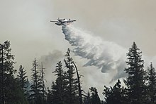
Strong Diablo winds continued to drive fire activity, but helped clear smoke westward, allowing for increased aircraft operations.
[47] Most firefighting activity was concentrated in the Lake Pillsbury area on the South Zone, in an effort to stop the fire from advancing further west.
Back-burns and mop up operations were continued on the north and east perimeters to strengthen the fire lines there.
[51] On September 18, evacuations were lifted in the Glenn County portion of the Mendocino National Forest, as the eastern flank of the fire was almost fully contained.
The entire August Complex was at 832,891 acres (337,059 ha) and was 31 percent contained, with the fire spreading on its southwestern flank.
[53] By September 21, a significant portion of the large, previously-unburned section of the Yolla Bolly-Middle Eel Wilderness between the North and South Zones had been burned over.
[54] On September 24, the North Zone was still holding south of State Route 36, in part due to back burning operations.
[55] On the South Zone, firefighters had made considerable progress halting the advance near Lake Pillsbury.
[55] September 28 saw increased fire activity on the North Zone, as the onset of a heatwave and Diablo winds drove the flames.
The fire jumped north of State Route 36 and traveled rapidly along the South Fork Trinity River canyon.
It also jumped west across Ruth Lake, burning towards the upper Van Duzen River drainage and Zenia.
Structures and power lines were reported destroyed in the Ruth Lake and Hettenshaw Valley areas.
[61] On October 5, the August Complex had grown to 1,002,097 acres (405,534 ha), with containment at 54 percent, with the majority of the growth coming from the northwestern and northeastern flanks of the fire.
[62] This made the August Complex the first "gigafire" (a fire spanning over a million acres) in the modern history of California.
[63] Due to an ongoing La Niña event, California got less rainfall than usual, and the rainy season started later than would typically be seen in October.
[66] On November 12, the Forest Service reported that the August Complex had finally reached 100% containment,[67][68] with the combined incident management being disbanded that same day.