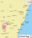
Australian Capital Territory
Section 125 of the new Australian Constitution provided that land, situated in New South Wales and at least 100 miles (160 km) from Sydney, would be ceded to the new federal government.
The territory was transferred to the federal government by New South Wales in 1911, two years prior to the capital city being founded and formally named as Canberra in 1913.
[24] The principal group occupying the region were the Ngunnawal people, with the Ngarigo and Walgalu living immediately to the south, the Wandadian to the east, the Gandangara to the north and the Wiradjuri to the north-west.
While working on the project, Charles Throsby learned of a nearby lake and river from the local Indigenous peoples and he accordingly sent Wild to lead a small party to investigate the site.
[27] The issue of the Murrumbidgee was solved in 1821 when Throsby mounted a third expedition and successfully reached the watercourse, on the way providing the first detailed account of the land that now comprises the territory.
[28] The first land grant in the region was made to Joshua John Moore in 1823, and European settlement in the area began in 1824 with the construction of a homestead by his stockmen on what is now the Acton Peninsula.
[29] The gold rushes prompted the establishment of communication between Sydney and the region by way of the Cobb & Co coaches, which transported mail and passengers.
Over the succeeding years, the Ngunnawal and other local indigenous people effectively ceased to exist as cohesive and independent communities adhering to their traditional ways of life.
[26] Those who had not succumbed to disease and other predations either dispersed to the local settlements or were relocated to more distant Aboriginal reserves set up by the New South Wales government in the latter part of the 19th century.
In 1906 and after significant deliberations, New South Wales agreed to cede sufficient land on the condition that it was in the Yass-Canberra region,[22] this site being closer to Sydney.
[22][33] Government surveyor Charles Scrivener was deployed to the region in the same year to map out a specific site and, after an extensive search, settled upon the present location,[34] basing the borders primarily on the need to secure a stable water supply for the planned capital.
Land within the territory is granted under a leasehold system, with 99-year residential leases sold to buyers as new suburbs are planned, surveyed, and developed.
[38] In an arrangement inspired by Georgism, the ideas of 19th-century American economist Henry George, leaseholders had to pay 5% of the unimproved value of the underlying land in rent until the Gorton government abolished it in 1970.
[26] After Griffin's departure following difficulty in implementing his project,[40] the Federal Capital Advisory Committee was established in 1920 to advise the government of the construction efforts.
[44] The National Capital Development Commission ended four decades of disputes over the shape and design of Lake Burley Griffin and construction was completed in 1964 after four years of work.
[45] Nevertheless, in 1988, the new federal minister for the territory Gary Punch received a report recommending the abolition of the National Capital Development Commission and the formation of a locally elected government.
[51] ACT chief minister Andrew Barr said NSW premier Dominic Perrottet had agreed to a proposed border change of 330 ha (1.3 sq mi) in the Ginninderra watershed.
These formations became exposed when the ocean floor was raised by a major volcanic activity in the Devonian forming much of the east coast of Australia.
Interest in forestry began in 1915 with trials of a number of species including Pinus radiata on the slopes of Mount Stromlo.
There are seven districts (with an eighth currently under construction), each of which is divided into smaller suburbs, and most of which have a town centre which is the focus of commercial and social activities.
[92] In 1967, the then National Capital Development Commission adopted the "Y Plan" which laid out future urban development in the territory a series of central shopping and commercial area known as the 'town centres' linked by freeways, the layout of which roughly resembled the shape of the letter Y,[93] with Tuggeranong at the base of the Y and Belconnen and Gungahlin located at the ends of the arms of the Y.
[99] As of May 2004, 30% of people in the territory aged 15–64 had a level of educational attainment equal to at least a bachelor's degree, significantly higher than the national average of 19%.
The Australian Defence Force Academy (ADFA) and the Royal Military College, Duntroon (RMC) are in the suburb of Campbell in Canberra's inner northeast.
ADFA teaches military undergraduates and postgraduates and is officially a campus of the University of New South Wales while Duntroon provides Australian Army Officer training.
The Prime Minister's XI (Cricket), started by Robert Menzies in the 1950s and revived by Bob Hawke in 1984, has been played every year at Manuka Oval against an overseas touring team.
[103] Many Commonwealth government buildings in the territory are open to the public, including Parliament House, the High Court and the Royal Australian Mint.
[103][109] The Canberra Museum and Gallery in the city is a repository of local history and art, housing a permanent collection and visiting exhibitions.
[133] NETS provides a dedicated ambulance service for inter-hospital transport of sick newborns within the ACT and into surrounding New South Wales.
[143] CDC Canberra provides bus services between the territory and nearby areas of New South Wales (Murrumbateman and Yass)[144] and as Qcity Transit (Queanbeyan).
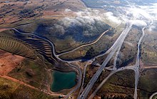
[164] Icon Water owns the territory's two wastewater treatment plants, located at Fyshwick and on the lower reaches of the Molonglo River.