Molonglo River
The river rises on the western side of the Great Dividing Range, in Tallaganda State Forest at 1,130 metres (3,710 ft) and flows generally from south to north before turning north-west, through Carwoola and the outskirts of Queanbeyan, where it has confluence with its major tributary, the Queanbeyan River, and then continues through Canberra, where it has been dammed by the Scrivener Dam to form Lake Burley Griffin.
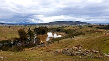
Over its 115 kilometres (71 mi) course, the Molonglo River alternates several times between long broad floodplains and narrow rocky gorges.
[citation needed] Where the river flowed through what is now Canberra, it was probably known after the Ngambri people, transcribed as Kembury, Canberry, and other transcription variations.
Despite government funded rehabilitation programs in 1976, some toxic leachates still enter the river from the Captain's Flat mine site.
Restocking commenced in the 1970s and continued through 1980s have re-established Murray Cod and Golden Perch in the lake and a short stretch of river upstream.