Automatic identification system
[citation needed] Although technically and operationally distinct, the ADS-B system is analogous to AIS and performs a similar function for aircraft.
Port authorities or other shore-based facilities may be equipped with receivers only, so that they can view the local traffic without the need to transmit their own location.
Global AIS transceiver data collected from both satellite and internet-connected shore-based stations are aggregated and made available on the internet through a number of service providers.
Typical data includes vessel name, details, location, speed and heading on a map, is searchable, has potentially unlimited, global range and the history is archived.
The 2002 IMO SOLAS Agreement included a mandate that required most vessels over 300GT on international voyages to fit a Class A type AIS transceiver.
Low-cost Class B transceivers became available in the same year triggering mandate adoptions by numerous countries and making large-scale installation of AIS devices on vessels of all sizes commercially viable.
In parallel, governments and authorities have instigated projects to fit varying classes of vessels with an AIS device to improve safety and security.
In November 2009, the STS-129 space shuttle mission attached two antennas—an AIS VHF antenna, and an Amateur Radio antenna—to the Columbus module of the ISS.
Starting from May 2010 the European Space Agency is testing an AIS receiver from Kongsberg Seatex (Norway) in a consortium led by the Norwegian Defence Research Establishment in the frame of technology demonstration for space-based ship monitoring.
In August 2017, Spire Global Inc. released an API that delivers S-AIS data enhanced with machine learning (Vessels and Predict) backed by its 40+ constellation of nano-satellites.
A great strength of S-AIS is the ease with which it can be correlated with additional information from other sources such as radar, optical, ESM, and more SAR related tools such as GMDSS SARSAT and AMVER.
Due to its growing use over time, in some coastal areas (e.g., the Singapore Strait, China's megaports, parts of Japan) there are so many vessels that the performance of AIS has been affected.
For this reason VHF Data Exchange System (VDES) has been developed:[18] it will operate on additional new frequencies and will use them more efficiently, enabling thirty-two times as much bandwidth for secure communications and e-navigation.
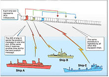
Data is transmitted via a tracking system which makes use of a self-organized time-division multiple access (SOTDMA or STDMA) datalink designed by Swedish inventor Håkan Lans.
Products that have not been tested and certified by a competent authority, may not conform to the required AIS published specification and therefore may not operate as expected in the field.
[37] The International Association of Marine Aids to Navigation and Lighthouse Authorities (IALA-AISM) now established a process for collection of regional application-specific messages.
Heading information, position (latitude and longitude), "speed over ground", and rate of turn are normally provided by all ships equipped with AIS.
An AIS transceiver normally works in an autonomous and continuous mode, regardless of whether it is operating in the open seas or coastal or inland areas.
[citation needed] The entire Chinese coastline is covered with approximately 250 base stations in hot-standby configurations including 70 computer servers in three main regions.
Hundreds of shore-based users, including about 25 vessel traffic service (VTS) centers, are connected to the network and are able to see the maritime picture, and can also communicate with each ship using SRMs (Safety Related Messages).
The signal can travel a maximum of 75 kilometers [42] As there are a multitude of automatic equipment transmitting AIS messages, to avoid conflict, the RF space is organized in frames.
[44] Data exchange at open radio frequencies renders the AIS services vulnerable to malicious transmissions, including spoofing, hijacking, and availability disruption.
[49] The AIS services include government-managed base stations that operate Vessel Traffic Systems (VTS) and coastal surveillance coverage.
[54] On 18 June 2021 AIS receivers in Chornomorsk, Ukraine, reported HMS Defender and HNLMS Evertsen allegedly sailing towards Sevastopol Russian military base in annexed Crimea while the ships were safely moored in Odesa, according to numerous live port webcam feeds and witnesses, which implied that falsified AIS data was injected into the system by an unknown party.
[56] In March 2021 a similar incident was registered by Swedish armed forces whose ships were incorrectly presented by AIS as if they were sailing in Russian waters near Kaliningrad.
[58] Todd Humphreys, director of the Radionavigation Laboratory at the University of Texas at Austin, stated that "While I can't say for sure who's doing this, the data fits a pattern of disinformation that our Russian friends are wont to engage in.
In 2019, Iran state actors spoofed AIS signals to force a British oil tanker, the Stena Impero, to sail into Iranian waters, where it was seized and leveraged as a bargaining chip in exchange negotiations.
Its use ranged from Chinese fishing fleets hiding operations in protected waters, tankers concealing stops in Iranian oil ports, container ships obfuscating journeys in the Middle East, and reportedly also weapons and drug smuggling.
[61] In March 2021, a United Nations Security Council investigation into sanction evasions by the Democratic People’s Republic of Korea found that unflagged vessels delivered refined petroleum products to the DPRK from May 2020 to October 2020.
[62] Satellite imagery on 8 July 2020 recorded one of the investigated ships, the An Ping, delivering unreported refined petroleum at Nampo, North Korea.