Avalon Marshes Partnership
[3] By around 6,500 to 6,000 years ago the marshes had become reed beds interspersed with rhynes (ditches) and open water, and parts of the area were in turn colonised by wet woodland.
[2] The formation of the bog was aided by the Somerset Levels' large water catchment area, high rainfall in the Mendips and Blackdown Hills and raised marine clay deposits which restricted drainage to the sea;[6] the same impermeable material underlies the peat, which in places is up to 7.3 metres (24 ft) thick.
[9] Much of the landscape was owned by the church in the Middle Ages when substantial areas were drained and the rivers diverted, but the raised bogs remained largely intact.
Only the Inclosure Acts of the 18th century, mostly between 1774 and 1797, led to significant draining of the peat bogs, although the River Brue still regularly flooded the reclaimed land in winter.
[14] By the twentieth century, large areas of the levels were exploited to meet the demands of horticulture for peat,[4] the owners of the workings, Fisons, reaching an annual production of 250,000 tonnes (250,000 long tons) in the early 1990s.
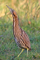
[2] Water levels in reed beds are managed using sluices, pipes and wind-pumps, with deep wide ditches to restrict reed encroachment and provide a habitat for fish, particularly the common rudd, introduced to provide food for the bitterns at Ham Wall,[2] which along with Lakenheath Fen in Suffolk, has been a key part of a bittern recovery programme initiated in 1994 as part of the United Kingdom Biodiversity Action Plan.
[22] Shapwick Moor had been drained and converted to arable farmland when it was enclosed in the eighteenth century, but since its purchase it has been managed as hay meadow, with late summer cutting, no fertilisers, and grazing by cattle.
[24] The Huntspill River is an artificial waterway built in World War II to supply water to a secret RDX explosives factory at Puriton.
With the factory long closed, the river is now a National Nature Reserve managed by the Environment Agency with reed beds, less steep banks and tree planting.
Additionally, the South West Heritage Trust have built historic replica buildings; a Roman Villa[26] and a Saxon Long Hall.
[30] The main access to the reserve on leaving the car park is the Ham Wall loop; this follows the north bank of the canal, crosses at a bridge and returns via a parallel grass track, 2.7 kilometres (1.7 mi) in total.
From the car park the old railway path runs the 4 kilometres (2.5 mi) length through the reserve until it meets with the Westhay - Shapwick road.
Two machines are used, an amphibious Truxor tracked reed cutter to harvest wetter areas, and a faster Softrak for islands and where water levels have been lowered.
[34] Other joint schemes include improved pedestrian and cycle access,[35] and the provision of visitor facilities at Ashcott corner between the Ham Wall and Shapwick Heath reserves.
The formerly rare great white egret first bred in 2012 and has nested in the area in small numbers every year since on the reserve and the neighbouring wetlands.
An influx in 2017 led to six pairs attempting to breed at Ham Wall, four successfully, and 30 birds were present in the area in January 2018.
A winter evening roost of common starlings is one of the largest in the UK, and attracts visitors to see hundreds of thousands, sometimes millions, of these birds assemble before descending into the reed bed at Ham Wall and Shapwick Heath.
[2] Rare visitors to the Ham Wall reserve in recent years include a collared pratincole in 2016,[38] a singing male pied-billed grebe in 2013,[39] a blue-winged teal in 2012 and a squacco heron in 2011.
Sites for European adder include Westhay Moor and Shapwick Heath, and slow worms and common lizards are also found in suitable habitat.
[45] Greater unpredictability in the UK climate may lead to heavy summer rains which would adversely affect ground-nesting birds, invertebrates and other wildlife.
[48] Despite Environment Agency planning, recent significant river flooding events occurred on the Levels in November 2012[51] and following Cyclone Dirk in winter 2013–2014,[52] the latter leaving 6,900 hectares (17,000 acres) of agricultural land under water for over a month.
[53] Water-based sport and recreation elsewhere in the Levels could possibly enable non-native species to invade the wetlands, and the number of visitors to the area can cause congestion on local roads, particularly those coming for the winter evening starling roost.