Avondale Heights
[1] Avondale Heights is located on a plateau bounded by a large bend of the Maribyrnong River to the east, south, and west, and to the north by Buckley Street.
Originally known as Maribyrnong West, when the Council undertook to change the name, postal authorities drew attention to the existence of Avondale in Queensland.
They imagined children's playgrounds, social centres, nature reserves and links with an intricate system of pedestrian ways.
On 10 October 1940, James White dug up an ancient human skull (now known as the Keilor Cranium) on the banks of the Maribyrnong River.
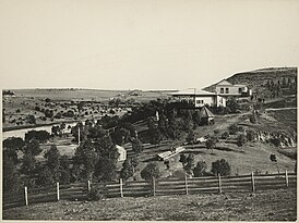
In 1835 with the initial settlement of Melbourne, Edmund Davis Fergusson and Michael Solomon established a pastoral holding in the Avondale-Sunshine area.
This was the lowest crossing point on the Saltwater (Maribyrnong) River, and was for many years the only overland route from Melbourne to Geelong and further west.
The MMBW reconstructed the ford and the riverbanks nearby in the 1980s, adding large basalt boulders to form stepping stones across the river.
This was due to the sale of the old Kangan Batman TAFE site to private investors, to develop medium density housing.