Badajoz bastioned enclosure
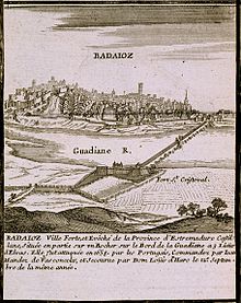
Its strategic location at the crossroads of two major routes: one from Castile to Andalusia, and the other from the plateau to Lisbon, along with its status as a border city with Portugal, has led to both advantages for Badajoz's development and numerous conflicts involving various armies over the centuries.
[4] The city of Badajoz, specifically the oldest area, located in the highest part of the promontory called Cerro de la Muela, was protected by an enclosure built during the Islamic period, with its fortress known as the Alcazaba.
During Islamic times, Badajoz was encircled by a defensive wall that safeguarded the al-qasbah (ksar), the citadel, which served as the administrative center and residence of the rulers of the Kingdom of Badajoz—one of the largest taifas of the Iberian Peninsula.
Located on the right bank of the Guadiana River, north of the city, on a significant promontory known as Orinaza Hill, this fort was considered the first of its kind for defensive fortifications.
It then turned west and south, passing through the bastions of San José, Santiago, Santa María, and Trinidad Gate, before reconnecting with the defensive wall protecting the Alcazaba.
In 1580, Philip II relocated the Court and the majority of his army to Badajoz, where he resided for eleven months, effectively annexing Portugal into the Hispanic Monarchy.
This development was necessitated by the need to defend Badajoz, the seat of the General Captaincy of the Royal Army of Extremadura, amidst the hostilities that led to the Portuguese Restoration War.
[15][14]Gradually, the old defensive wall was replaced by a new fortification that began at the Muslim citadel, followed the left bank of the Guadiana River, and then turned west and south, where the bastions of San Vicente and Palma Gate were constructed.
Additionally, half bastions were placed to guard the access gates, bartizans were added at the vertices where two curtain walls met, and features such as moats, lunettes, and ravelins were included to hinder enemy actions.
[10] A bastion or bulwark is a fortified redoubt that projects outward from the main body of a fortress, generally located at the corners of the curtain walls, as a strong point of defense against the enemy.
The defenders, consisting of French and Spanish troops loyal to Philip of Anjou, faced the attackers, who established their artillery batteries across the Rivillas stream, near "La Picuriña" and the hermitage of San Roque.
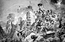
[21] During the Peninsular War, the redcoats of the future Duke of Wellington, led by General Thomas Picton of the 3rd Division, entered this area in 1812 following the third assault for the liberation of Badajoz.
This decision faced criticism from military engineers responsible for the city's defense, as the area was lower and more vulnerable to attacks from the heights of "La Picuriña."
[36] In the late 19th century, an attempt was made to add a postern to the bastion, intended as a small service gate for easy communication with the outside and for storage purposes.
The western curtain wall includes three embrasures in its upper section designed to provide defensive fire and protect against potential assaults on the moat of the Bastion of San Vicente.
A coat of arms of Great Britain is situated nearby as a tribute from the Cortes of Cadiz to Lord Wellington for his role in the 1812 conquest of Badajoz from the French.
[48]Designated as number 11 on the Plan of Gates, it is situated adjacent to the San Roque Bridge, at the beginning of the Pilar roundabout, and directly in front of the Monument to the Fallen Hero.
The fort was connected to the gate by a covered road, which provided protection from enemy fire and allowed for the secure relief of troops, as well as the resupply of ammunition, food, and water.
However, the Bastion of San Juan was demolished at the end of the 20th century to make way for road traffic, resulting in an irreparable loss of this historical element of the defensive enclosure.
It extends slightly beyond the width of the defensive wall and features façades adorned with semicircular arches and pediments on the cornices, topped by three spheres that retain their original Baroque style.
In addition to its defensive and passage control functions, the Palmas Gate also serves a symbolic role akin to a triumphal arch, honoring the sovereigns and kings of its time.
[62] The gate is located near the "Bridge of Autonomy", adjacent to a traffic circle featuring sculptures of the heads of Luis Alvarez Lencero, Jesus Delgado Valhondo, and Manuel Pacheco, all poets from Extremadura.
A covered way originating from the gate extended to the Fort of San Cristóbal, situated on a hill that commands the right bank of the river, overlooking the old city of Badajoz.
Above the gate, a bartizan is mounted on cantilevers and includes an arrowslit floor, allowing defenders to observe and protect the entrance without exposing themselves to enemy fire.
The site where the fort stands, Cerro de San Cristóbal, was once the location of the Dukes of Orinaza's palace, and Ibn Marwan planned to establish the city of Badajoz there in the 9th century.
Additionally, bartizans were positioned at the corners of the perimeter, and the lower part of the wall included embrasures designed to accommodate firearms and artillery to protect the moat in the event of an enemy assault.
[85] The forts of Cabeza del Puente and San Cristóbal played a crucial role in the conflict between Spain and Portugal, enduring numerous attacks and sieges.
The side of the triangle semi-parallel to the curtain wall where the ravelin is arranged does not usually have defenses so that, in case it is taken by the enemy, they cannot chemin de ronde and make themselves strong in it.
The area between this ravelin and the rest of the fortifications could be inundated; therefore, during the siege of 1812, a dam was built downstream of the Rivillas stream to raise its water level by several meters.
[95] Squares of arms, which served as open spaces for troop assembly and maneuver, were present in several bastions, in the vicinity of the ravelin of San Roque, the Auditorium, and in the hornwork of the Head of the Bridge.