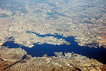
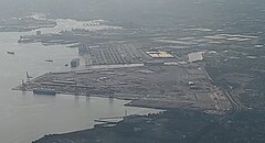
Port of Baltimore
[3] On March 26, 2024, the collapse of the Francis Scott Key Bridge blocked ships' access to the port; the channel was fully reopened on June 10, 2024.
[4][5] English royal and proprietary land grants from 1661 were combined in 1702 by James Carroll, who named it Whetstone Point because of the landform shape resembling a sharpening stone.
In 1776, local citizenry erected earthworks for port defense during the American Revolutionary War known as Fort Whetstone.
It soon became the colony's main shipbuilding center, with many shipyards, famed for the construction of the unique styled Baltimore clipper smaller-sized sailing schooners.
The Continental Navy ordered their first frigate warship, USS Virginia, from George Wells at Fells Point in 1775.
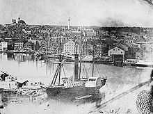
[8][9] After Baltimore's founding, the waterfront developed into drydocks, warehouses, ship chandlers, and industry, including mills, which were built behind the wharves.
In what is now Canton, further southeast of Baltimore and Fells Point along the Patapsco River, John O'Donnell's plantation was developed in the early 1800s for worker housing and industry, including the Canton Iron Works owned by Peter Cooper and later Horace Abbott during the Civil War and others.
[13] By the end of the nineteenth century, European ship lines had terminals for emigrants from Britain, Ireland, Germany, and Poland.
In 1790, the state government began systematic dredging using a "mud machine", which used a horse-drawn drag bucket, later upgraded with steam power.
He excavated a new channel starting from the older channel at a point just northwest of Seven Foot Knoll and running south to the mouth of the Magothy River, where it turned to the south-southeast and continued to Sandy Point, just north of the present location of the Chesapeake Bay Bridge.
Enlarged and extended to access various facilities within the port, the Brewerton and Craighill Channels continue to be used to the present, essentially unaltered in configuration.
[15] Federal lighthouse construction in the bay began in the 1820s, and one early project was the erecting of range lights to guide ships into the Patapsco.
The North Point Range Lights were lit in 1822, marking a path roughly the same as that of the current Craighill Cutoff Channel.
The Craighill Channel Lower Range Rear Light enjoys the distinction of being the tallest lighthouse in Maryland.
[22] Salvage crews worked for 11 weeks to remove the Dali and the bridge wreckage, and on June 10, 2024, the channel was fully reopened.