Barabanki district
Barabanki district is situated between 27°19′ and 26°30′ north latitude, and 80°05′ and 81°51′ east longitude; it runs in a south-easterly direction, confined by the nearly parallel streams of the Ghaghara and Gomti.
During the Indian Rebellion of 1857, the whole of the Barabanki talukdars joined the mutineers, but offered no serious resistance following the capture of Lucknow.
[7] Previously, under the Nawabs of Awadh, the area that would become Barabanki district was divided between five chaklas: Daryabad-Rudauli, Ramnagar, Dewa-Jahangirabad, Jagdispur, and Haidargarh.
After, Tarain 1192, Moslems again attacked this region and Ayodhya but were not very successful till the reign of Khiljis and Firoz Tuglaq.The foreigners followed a policy of religious persecution and conversions.
They also settled many foreigners and gave them fertile tracts in Ramnagar, Daryabad, Zaidpur, Rudauli areas.
[13] Rudauli was occupied c. 700 AH, in the reign of Alla-ud-din Khilji, whose forces had destroyed nearly every remaining seat of Chhattri power.
The villages of Barauli and Barai, near Rudauli, were occupied and became large estates until about the middle of the fifteenth century.
The mysterious tribe of Kalhans, which numbers some twenty thousand persons, are said to be descended from Achal Singh, who came in as a soldier of fortune with Dariab Khan about 1450 AD.
The battleground was the Oudh borderland between Sharqis of Jaunpur (where Ibrahim Shah Shargi reigned) and the Lodis of Delhi.
Oudh clans, said to have emigrated from Gujarat, included the Kalhans, the Ahban, the Pan war, the Gahlot, the Gaur, and the Bais.
Newal Rae, the naib of wazir Safdar Jang, was defeated and killed at the Kali river by the Bangash Afghans of Farukhabad, who then overran the province except a few of the fortified towns.
The Mughal authority might have been overthrown had the Oudh Chhattris revolted at this time, but they waited until Jang had bribed or beaten the Rohillas out of the country in 1750 AD (1164 AH).
[3] The tribes gathered themselves together under the leadership of Raja Anup Singh of Ramnagar Dhameri, the Janwar of Balrampur, the Bisens of Gonda, and numerous other lords.
The Shekhzadas of Lucknow came out to meet the enemy, joined by the Khanziidas of Mahmudabad and Bilahra, who were connected with them by marriage.
[3] The Musalmans, headed by Nawab Muizz-ud-din Khan of Mahmudabad, were victorious in battle at Chheola Ghat on the Kalyani, on the road to Lucknow.
The Raikwars were proportionately depressed; the estates of both Baundi and Ramnagar were divided, and but a few villages left with the raja.
They offered no resistance, however, of any moment to the advance of the British troops after the capture of Lucknow in the battle of Nawabganj.
However, due to the stagnation of water in the immediate vicinity of the town, and to the prevalence of fever, the headquarters was moved in 1859 to Nawabganj, Bara Banki.
[17] During 1869 census of Oudh, thirteen large towns or kasbahs were identified in the district:[18] Nawabgunj, Musauli, Rasauli, Satrikh, Zaidpur, Sidhaur, Dariabad, Ichaulia, Rudauli, Ram Nagar, Bado Sarai, Kintoor and Fatehpur.
In the north, the topography is broken by a 6.1-metre (20 ft) ridge running parallel to the Ghaghra at a distance of 1.6 to 4.8 km (1 to 3 mi), which is said to indicate the former right bank of this river.
The principal ferries are at Kaithi, Kamiar, and Paska Ghat; a floating bridge operates at Bahramghat during the cold season.
Like the Ghagra, it runs in a south-easterly direction, has a well-defined bank and a stream which is fordable in the dry weather, when it is about 37 m (120 ft) wide.
Their general characteristics are the same: they have significant flows during rains which have carved steep and rugged banks broken by innumerable ravines.
[3] There are numerous tanks and jheels,[clarification needed] especially in the tehsils of Daryabad, Ram Sanehi Ghat, and Nawabganj.
[28] Barabanki District is divided into six subdivisions, popularly known as tehsils: Nawabganj, Fatehpur, Ramsanehi Ghat, Haidergarh, Ram Nagar and Sirauli Ghauspur.
The development blocks are: Banki, Masauli, Dewa, Harakh, Fatehpur, Haidergarh, Dariyabad, Suratganj, Siddhaur, Pure Dalai, Nindura, Trivediganj, Ram Nagar, Sirauli Ghauspur and Banikodar.
[clarification needed][28] These police stations are: Haidergarh, Satrikh, Dariyabad, Baddupur, Dewa, Kursi, Zaidpur, Mohammadpur, Ram Nagar, Fatehpur, Safderganj, Kotwali, Ramsanehi Ghat, Asandra, Subeha, Tikait Nagar, Lonikatra, Masauli, Kothi, Ghungter, Badosarai and Jahangirabad.
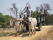
Sitting members are:[36] Following is the list of public amenities (1999–2002 data):[28] Area covered under water supply using taps/ handpumps of India Mark-2: The district's economy is primarily based on agriculture.
[37] Agriculture, bio-gas plants, animal husbandry, and small-scale industries provide direct and indirect employment.
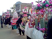
[73][74] The plant was set up by Technical Associates Ltd.[75] In 2011–12 almost 2 million people visited the twin sites of Lodheshwar Mahadev Mandir and Deva Sharif shrine.