Barguzinsky Bay
Another 4.5 km due east is Cape Dukhovy; between the two is a broad curved bay with mostly sandy beach, where the town of Maksimikha is located.
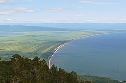
It runs due north along the Chivyrkuisky Isthmus, curving towards northwest at the end, in a smooth arc 27 km long.
That part of the shore is a long sandy beach, broken only by the mouth of the Barguzin River (5.5 km north of Cape Kholodyanki, at 53°25′35″N 108°59′27″E / 53.4265°N 108.9909°E / 53.4265; 108.9909).
That part of the shore is again a narrow strip of large pebbles and rocks, overlooked by steep terrain; except at the very tip of the peninsula.
[3][5][1] Road R438 runs along the southeast side of Barguzinsky Bay to Ust-Barguzin, then turns east along the river to the city of Barguzin.
That is the start of a popular hiking trail that leads up to Mount Markov, the highest point of the Holy Nose.
[5] A luxury hotel was built at Glinka in 1989, but was destroyed by fire shortly after opening, leaving only the cement and stone foundations.