Barnim Plateau
Traditionally the plateau is divided into the Upper and Lower Barnim, separated by a line running between Strausberg and Eberswalde.
Until the growth of Berlin in the 19th century, Barnim was only sparsely populated; in the eastern portion this continues to be the case.
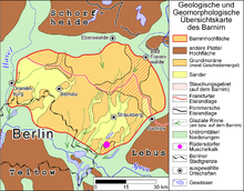
The southern edge of Barnim in the vicinity of Rüdersdorf unusually contains widespread deposits of limestone, Buntsandstein and Muschelkalk.
The limestone deposits gave birth to an expansive quarry which provided building materials for the expanding Berlin, an example of which being the tower of St. Mary's Church.
In the last glacial period, more commonly known as the last time the Earth experienced an ice age, glaciers reached 60 kilometres south of Barnim.
The following streams drain into the Havel and Spree drainage basins: The following tributaries flow into the Oder: Despite being an area of Young Drift, Barnim has relatively few lakes.
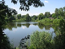
At the outwash plain, the deposition of glacio-fluvial sediment has led to a higher number of lakes, the most well-known of which are Wandlitzer See, Gamensee and Straussee.
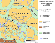
[2] While the Slavic peoples tended to settle in lowland parts of Barnim near the relatively few areas, subsequent settlement of the plateau began in the 1230s by the House of Ascania under the rules of John I, Margrave of Brandenburg and Otto III, Margrave of Brandenburg as part of the German eastward expansion.
Conflicts over the question of territorial sovereignty contributed to the Teltow and Magdeburg Wars between 1239 and 1245 which were won by the Ascaniers.
In a measure intended to cement Ascanian rule, the House founded the Chorin monastery and the Friedland convent, which is now a ruin.
At the end of the 19th century the industrial revolution in Germany resulted in strong population growth in Berlin, which expanded into the plateau.