Barnsley
[3] Historically in the West Riding of Yorkshire, Barnsley is located on the M1 corridor between the cities of Sheffield to the south and Wakefield to the north.
Doncaster is to the east, Huddersfield to the north-west, and Manchester lies west across the Peak District to which it is connected to via the A628 road.
Barnsley's culture is rooted in its industrial heritage and it has a tradition of brass bands, originally created as social clubs by its mining communities.
Norman landowners increased their revenues and established new towns such as Barnsley, Doncaster, Hull, Leeds, Scarborough and Sheffield, among others.
The monks built a town where three roads met: the Sheffield to Wakefield, Rotherham to Huddersfield and Cheshire to Doncaster routes.
[5] The monks erected a chapel of ease dedicated to Saint Mary, which survived until 1820 [citation needed], and established a market.
In 1249, a Royal charter was granted[6] to Barnsley permitting it to hold a weekly market on Wednesdays and annual four-day fair at Michaelmas.
On 1 January 1850 the Manchester and Leeds Railway opened Barnsley Exchange station, close to the town centre.
He wrote very critically of the council's expenditure on the construction of Barnsley Town Hall and claimed that the money should have been spent on improving the housing and living conditions of the local miners.
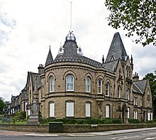
[11] The Town Hall itself is visible behind some gardens; the building is made of white stone and has an impressive clock tower.
In 1974, following the Local Government Act 1972, the county borough was abolished and Barnsley became part of the Metropolitan Borough of Barnsley in the new county of South Yorkshire, along with nine urban districts and parts of two rural districts of the surrounding area, including many towns and villages including Penistone and Cudworth.
Barnsley is located in the valley of the River Dearne at the eastern foothills of the Pennines, near the uplands of the Peak District to the west.
Geologically, the town is located within the area of the South Yorkshire Coalfield, consisting of the middle coal measures and sandstones laid down in the Carboniferous period.
It is in place to reduce urban sprawl, prevent the towns in the Barnsley/Dearne Valley conurbation from further convergence, protect the identity of outlying communities, encourage brownfield reuse, and preserve nearby countryside.
This is achieved by restricting inappropriate development within the designated areas, and imposing stricter conditions on permitted building.
Larger outlying communities such as Cudworth, Dodworth, Kendray, Monk Bretton, and Worsbrough are also exempt from the green belt area.
However, nearby smaller villages, hamlets and rural areas such as Swaithe, Smithley, Low Laithes, and Upper Norcroft are 'washed over'[definition needed] by the designation.
Major companies in Barnsley include online retailer ASOS, the largest cake bakery in Europe, Premier Foods (formerly Lyons Bakery) who make the Mr Kipling Cake brand, Ardagh Glass (glass bottle makers), Symphony Kitchens, Premdor, several double glazing joinery manufacturers and a number of other large food manufacturers.
Most of these businesses are based on industrial parks outside the town centre including many on reclaimed former coal mine sites.
This western part includes the market town of Penistone and Wentworth Castle and its Grade I listed gardens,[20] Cannon Hall Park and Museum,[21] Cawthorne Jubilee Museum,[22] Wortley Hall and gardens,[23] and Wortley Top Forge (16th century Forge).
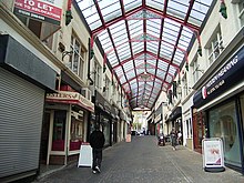
The area around Cheapside and May Day Green, the Metropolitan Centre, is home to the market and many national high street chains such as Marks & Spencer, Carphone Warehouse, Vodafone, Boots, and The Body Shop.
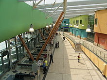
The Civic, in Barnsley town centre, is a multi-purpose performance venue in a grade II listed building.
The School of Art occupied the Public Hall from 1878 to 1948, which was also used as first headquarters and billets for "Barnsley Pals" during World War I.
The Civic was re-opened in March 2009 after a major redevelopment, which included provision for a theatre and public art gallery.
[39] Barnsley is home to a tradition of brass bands, which were originally created as social clubs for the mining communities.
[citation needed] There is a live rock and hip hop music scene, which reached its height in the Britpop years, around 1997, due to its close proximity to Sheffield and Manchester.
[citation needed] Barnsley is the home of several live music venues such as The Underground, The Garrison, The Old No 7 and The Old School House.
It now hosts Barnsley Live, an annual music festival featuring local acts that takes place in the town centre over a weekend in June.
[citation needed] In December 2023 a Christmas carol, written by local musician Arthur Godfrey in 1933, was rediscovered in the archives of the Barnsley Chronicle.
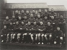
They played at the Miners Welfare ground in Dodworth until deteriorating player participation forced the club to fold 5 games into the 2013/14 season.