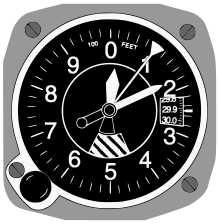
Altimeter
[2] A radar altimeter measures altitude more directly, using the time taken for a radio signal to reflect from the surface back to the aircraft.
The radar altimeter is used to measure height above ground level during landing in commercial and military aircraft.
After extensive research and experimentation, it has been shown that "phase radio-altimeters" are most suitable for ground effect vehicles, as compared to laser, isotropic or ultrasonic altimeters.
In aircraft, altitude determined using autonomous GPS is not reliable enough to supersede the pressure altimeter without using some method of augmentation.
[5] In hiking and climbing, it is common to find that the altitude measured by GPS is off by as much as 400 feet (122 metres) depending on satellite orientation.