Bastille (Grenoble)
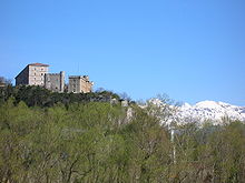
The Bastille is a fortress culminating at 476 m (1,561ft) above sea level,[1] located at the south end of the Chartreuse mountain range and overlooking the city of Grenoble, France.
The location was chosen for a fort because it facilitated the surveillance and control of the city of Grenoble, from the 19th century onward, as well as the valleys of the Isère and the Drac, all the while being difficult to attack and overthrow because of the cliffs and steep ground by which it is surrounded.
In December 1590, Lesdiguières,[N 1] head of the Huguenots in the Dauphiné, took control of the city of Grenoble from the Roman Catholic side during the eighth and last Wars of Religion.
With an army of 1,200 men gathered at Moirans, he marched towards Grenoble, passing through Saint-Martin-le-Vinoux and then over the spur of Mount Rachais called the Rabot, avoiding a fortified stronghold there.
[N 2] A single canon was positioned on the slopes of Mount Rachais, because this rocky spur was thought to be enough of a natural barrier to deter the advance of hostile forces.
First, a small fortified citadel around the Tour de l'Isle (a square tower built on the banks of the Isère, which today stands next to the Museum of Grenoble) so as to have a safe place to withdraw to in case the city was attacked.
In 1611, after a pause in the works, construction began on the fortifications descending from either side of the Bastille towards two new monumental gates situated at points on the banks of the Isère approximately 1 km apart.
A century after the construction of the Bastille, the military architect Vauban, during his first inspection of the fortifications of the Alps in September 1692, alerted the king, Louis XIV, to the weaknesses of the defences of Grenoble.
In his report, he described them as "weak, unfinished, poorly maintained, especially those of the Bastille", which he said were "badly cut, or rather a closed bauble, but without rhyme or reason, occupied by a vintner who is the governor, or at least who has the keys, with twelve cows, eight goats, a mare and a donkey for the whole garrison!".
In addition, due to the extensive flooding of the Isere in September 1733, and December 1741, what monopolized the minds of the authorities were what to implement to overcome these disasters' possible occurrence in the future.
[7] After the rout of Napoleon in Europe, the treaty of Fontainebleau in 1814, and that of Paris the following year put Grenoble back on the frontier opposite the Kingdom of Sardinia.
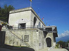
Built between 1840, and 1847, close to the old Rabot stronghold of the 15th century,[N 10] some fifty metres above the city, its role was to lodge up to 900 troops and their officers together with their artillery and a powder magazine far from the likely battlefront.
On the eastern flank, the Porte Saint Laurent[N 11] side of the hill, General Haxo decided on a much more direct route for the walls than the line used by Lesdiguières.
Tournadre, the head of the Engineers on site, opposed the plan because his allocated budget for the work on the hill could not be stretched to cover the enlargement of the rest of the city.
The Bastille was designed to defend Grenoble against attacks by Savoyards, the frontier being close by as Savoy was not yet part of France at the time the construction was finished.
In addition the invention of the modern canon (with rifled barrel and with shells replacing cannonballs ensuring far greater destructive power) rendered the fortress obsolete.
« I haven't the strength to describe the admirable view, which changes every hundred steps, that one enjoys from the Bastille... » It is with these words that Stendhal paid hommage to the site.
[11] The rest of the visitors go by car up the steep and narrow road from La Tronche, or on foot by one of the numerous signposted paths to reach the Bastille.
Positioned on 30 hectares (74 acres) of public land, the fortification has views towards the Vercors, Chartreuse and Belledonne mountains, and on a clear day the peak of Mont Blanc some 113 km (70 mi) distant can be seen.
It has been run since 1983 by the Régie du Téléphérique de Grenoble, a city-owned industrial and commercial business which manages the continuous upgrades required to keep the site attractive to visitors and residents.
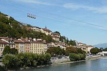
The route takes the cars across the Isère and over the roofs of the old Saint Laurent quarter before passing over a bastion of the curtain wall of the fort and then over the Rabot and various successive fortifications before arriving at the upper station.
In August 1976, the lower station was rebuilt slightly back from the quay so that the road no longer passed through an archway, and the spherical cabins ("the bubbles", 5 in summer and 4 in winter) made their first appearance.
At the bottom of the hill is the Saint Laurent district, the location of the Grenoble Archaeological Museum, and also the first burial site of the city dating from Gallo-Roman times.
Many tourists follow the underground passage leading from the entrance to the fort, giving access to the Mandrin Caves from which they can then exit at the opposite end of the glacis just by the second restaurant on the hill.
The paths that traverse the Bastille form part of the local and national GR footpath network which allows the visitor to continue their walks and hikes in the rest of the Chartreuse.
[15] It is situated at the foot of the hill, perched on a cliff close to the Porte de France, and is made up of a series of six terraces with retaining walls linked by steps, passageways and paths.