Ceintures de Lyon
Many of these structures proved to be ineffective in war due to advancement in weapon technology and the evolution of attack strategies at the time.
Austria was seen as the major threat to France at the time, and so protecting the east and south-east borders became a priority.
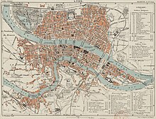
[4][5] The fortification of the city is divided into three sectors: The north was protected by the wall of Croix-Rousse and the structures between the Rhône and the Saône.
The east was defended by the Redoute du Haut-Rhône and Fort de la Vitriolerie on the left bank of the Rhône.
[9] During the Battle of Sedan on 2 September 1870, France learned that the Germans did not focus on enemy defenses to force cities to surrender.
[6] The war ended after the signing of the Treaty of Frankfurt on 10 May 1871, and the Ministry of the Armed Forces requested a report on the construction of military works for the defense of Lyon on 4 August 1871.
The ministry concluded that the forts constructed before 1870 (Rohault de Fleury) were obsolete because they were too close to the city, and that new rifled cannons could reach a distance of 50 kilometres (31 mi).
The proposed defenses included the construction of a fort and batteries on Mont Verdun to protect the right bank of the Saône, the forts of Vénissieux, Bron and Cusset to protect the left banks of the Rhône, and a fortification between the Rhône and the Saône at la Pape.
The explosion caused by this chemical was so powerful that the forts proved to be ineffective, and consequently their construction was temporarily put on hold.
[15][6] An experiment was conducted in 1886 by military engineers to verify the power of picric acid and its impact on their fortification systems.
[16] Fort Malmaison, which had recently been constructed near Paris, was the target of 171 test shells of all calibers containing picric acid.
The results showed that the impacts of the new shells left craters 6 meters in diameter, and were capable of breaching the powder magazine to create a huge explosion.
Download coordinates as: The second belt, called the Séré de Rivières system, consisted of twenty-six fortifications surrounding the suburban area of Lyon.