Bastrop County Complex Fire
On the afternoon of September 4, 2011, three separate fires ignited in the wildland–urban interface east of Bastrop, Texas, after strong winds caused by the nearby tropical storm snapped trees onto power lines.
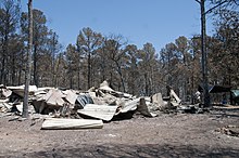
Homes were destroyed in ten subdivisions, of which Circle-D County Acres and Tahitian Village sustained the most significant property damage.
[2][4] Historical wildfire behavior in Texas has been strongly influenced by human activities and changes in land use, affecting the makeup and composition of the vegetation impacted by the fire.
[5] In the years leading up to the Bastrop County Complex, the only large wildfire in the area was the Wilderness Ridge Fire in 2009, which burned 1,491 acres (603 hectares).
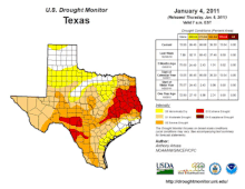
The drought began to materialize following a drier than average autumn and winter beginning in 2010, but it worsened to widespread and extreme levels after March 2011.
[3] The moisture content of all vegetation types within Bastrop County diminished to record lows during the course of the drought, making them increasingly susceptible to combustion.
Rainfall associated with the tropical storm did not expand west of Interstate 45, allowing the dry conditions in the Bastrop area to persist.
[2][4] The first fire was ignited by fallen power lines near Circle D-KC Estates, Texas, located 16 mi (10 km) northeast of Bastrop.
Strong winds caused a pine tree to snap 8 ft (2.4 m) above the ground, resulting in the upper trunk falling atop power lines and triggering sparks that reached the dry grass and leaf litter below.
[4][16][14] An investigation by Bluebonnet Electric Cooperative, which services the power lines in the region, arrived at similar conclusions for the cause of the fires.
The movement of Tropical Storm Lee east away from Texas slackened winds, though gusts remained in the 20–25 mph (32–40 km/h) range.
The combination of gusts with continued low relative humidity and strong atmospheric instability perpetuated environmental conditions conducive to large fire growth.
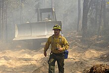
[3] The Bastrop County Complex remained 0 percent contained heading into the afternoon of September 5,[20] with its advance still unperturbed by firefighting efforts.
Over 250 firefighters were working on containing the fire's spread, aided by bulldozers to create firebreaks and TFS air tankers.
[32] Beneficial rains on September 24–25, including totals as much as 2 in (51 mm) in parts of Bastrop County, allowed firefighters to target hot spots more deeply embedded within the fire perimeter.
[38][39] The fire consumed 912 acres (369 hectares) and destroyed 25 homes and 2 businesses, prompting the evacuation of 200 people, but was 90 percent contained by September 8.
[3] FEMA authorized eight Fire Management Assistance Grants for Texas wildfires concurrent with the Bastrop County Complex, subsidizing firefighting equipment.
[15] The fire destroyed 1,660 homes and 36 businesses, accounting for approximately 59.4 percent of the structures caught within the wildfire's burn perimeter.
[68] The two people killed by the fire were found on September 6, 2011, after law enforcement and search crews combed through burned neighborhoods.
[3] The elimination of groundcover by the fire enabled extensive soil erosion within the park following heavy rainfall in January 2012, damaging archeological sites including those dating back to the Paleo-Indians.
[76] Their abundances were not strongly affected by the habitat loss in subsequent years,[80] though the fire may have pushed their populations beyond their typical range within Bastrop County.
[81] Similarly, the populations of other native amphibians and reptiles – namely the six-lined racerunner (Cnemidophorus sexlineatus), southern prairie lizard (Sceloporus consobrinus), and Hurter's spadefoot toad (Scaphiopus hurteri) – did not decrease as a result of the fire.
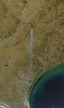
More than 16,200 acres (6,600 hectares) of forest burned in the wildfire, and over 24 million ft3 (680,000 m3) of timber was either destroyed or irreparably damaged, representing 78 percent of trees in the areas affected by the fire.
Softball-sized aggregations of charred pine trees were found in Rosanky, Texas, 15 mi (24 km) south of the Colorado River.
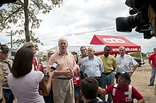
[14] In response to the wildfire, Governor of Texas Rick Perry forwent his presidential campaign stop in South Carolina and returned home on Tuesday, September 6, to "address the public and organize requests for more federal aid".
Mario Gallegos, Jim Dunnam, Kirk Watson, the Center for Public Policy Priorities and others opined that these budget cuts exacerbated conditions.
FEMA is actively working with state and local officials to conduct damage assessments and to identify areas where additional federal assistance may be warranted.
The concert was hosted by Kyle Chandler at the Frank Erwin Center in Austin on October 17 and featured several musicians including Christopher Cross, the Dixie Chicks, and Willie Nelson, raising over $500,000.
[94][95][96] On September 9, 2011, U.S. President Barack Obama granted a disaster declaration requested by Texas Lieutenant Governor David Dewhurst, authorizing approximately $16.1 million in federal monetary assistance for individuals in Bastrop County affected by the wildfire.
2, Bastrop Independent School District, Smithville Independent School District filed a lawsuit against Asplundh on April 1, 2016, alleging that the defendant failed to sufficiently prune trees that ultimately damaged power lines and sparked the fires while being aware of the associated risk given the prevailing weather conditions.