Tropical Storm Lee (2011)
[4] Elsewhere, the storm helped spread wildfires that destroyed homes and killed two people in Texas, and a traffic accident in Alabama resulted in one death.
[6] Combined with favorable upper diffluence, the moisture allowed for a perpetual area of disturbed weather to form; this, in return, contributed to the genesis of a weak tropical wave, or an elongated low-pressure feature at the lower levels of the atmosphere.
[7] The wave initiated a more-or-less westward, then west-northwestward drift across the Yucatán Peninsula toward the Gulf of Mexico, although it remained largely disorganized while doing so.
[8][9] After arriving in the gulf on August 31, the system failed to develop much under initially high wind shear; however, the National Hurricane Center forecast some potential for the formation of a tropical cyclone in a day or two.
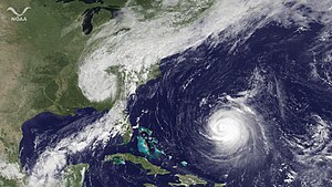
[10] Strong convection increased mainly to its east during the next day,[11] and by 23:00 UTC, data from a reconnaissance aircraft confirmed the presence of a closed circulation center.
At this point, the system was considered sufficiently organized to be upgraded to a tropical depression, with its center located 255 mi (360 km) to the southwest of the mouth of the Mississippi River.
[13] It exhibited a poor organization at the time; the circulation remained elongated, with a broad center of light winds removed from the sheared convective mass.
[16] Lee meandered erratically north-northwestward to northward for the rest of the day, and with a small upper low advecting dry air into the circulation any deep convection over its western semicircle remained scarce during that time.
[19] Stalling off the coast of Louisiana, the storm's windfield continued to expand and increase in strength, though two separate low-level centers became evident within the exceedingly large circulation later that day.
[20] Due to a large portion of circulation remaining over the warm waters of the Gulf of Mexico, Lee weakened more slowly than a typical tropical cyclone would as it moves inland.
[22] By that evening, Lee had weakened to a tropical depression in operational estimates, due to land interaction and continental air being advected into the system.
Lee had begun to interact with a strong upper-level trough (which would subsequently spawn Hurricane Nate in the Bay of Campeche a few days later) in the Mississippi Valley as it continued to move off to the east-northeast.
For the next several days, the new low made a large, counterclockwise loop over a portion of the Eastern United States, before dissipating on September 11, over western Tennessee.
[28] Mayor Mitch Landrieu declared a state of emergency for all of New Orleans; officials accordingly ordered the closure of floodgates and the preparation of rescue boats across the city.
[30] Additionally, the Louisiana parishes of Terrebonne and Lafourche distributed sandbags at several coastal locations[31] after specialists forecast torrential rainfall and flash flood warnings were issued.
Headwinds from Lee fanned a large fire north in Natchitoches Parish; about 400 acres of land, including 10 adjacent homes and several buildings, were set ablaze and subsequently destroyed.
A state of emergency was ordered for Jackson County; local fire stations initiated the free distribution of sandbags, and the harbor was closed off to all transient vessels.
Several roads were inundated in the coastal counties of Hancock, Jackson, and Harrison, with the latter two reporting considerable property damage due to the floods.
In Tishomingo County, a vehicle was caught in rushing waters while attempting to cross a flooded road; one person drowned, though its two other occupants were unharmed.
Multiple properties sustained damage and two homes were demolished by the winds; throughout southern Mobile, dozens of downed trees caused additional disruptions.
[46] Additionally, the brisk winds blew piles of sand from local beaches onto adjacent city streets,[47] and rough seas swept ashore numerous tarballs.
[49] As Lee headed north inland over the Gulf Coast, high winds were reported as fueling up to 60 separate brush fires across Texas, which was suffering from exceptional drought conditions.
[50] The largest of these occurred in Bastrop County just east of Austin, consuming roughly 34,000 acres; it forced thousands to evacuate and destroyed 1,554 homes.
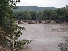
Most municipalities in Greater Binghamton and the Penn-York Valley saw water levels top the levees, inundating several downtown areas along the river.
[61] To the east, regions already suffering the aftereffects of flooding from Hurricane Irene almost two weeks earlier had those problems aggravated by 2–4 inches (51–102 mm) of new rain on saturated ground and rivers still swollen.
Heavy rain from the remnants of Tropical Storm Lee raised the creek "higher than anything we've seen in recorded history", according to a county official.

Tropical storm (39–73 mph, 63–118 km/h)
Category 1 (74–95 mph, 119–153 km/h)
Category 2 (96–110 mph, 154–177 km/h)
Category 3 (111–129 mph, 178–208 km/h)
Category 4 (130–156 mph, 209–251 km/h)
Category 5 (≥157 mph, ≥252 km/h)
Unknown