A4 road (England)
The A4 has gone through many transformations through the ages from pre-Roman routes, Roman roads (such as the one passing Silbury Hill),[2] and basic wagon tracks.
[6] During the 1820s, the employment of good surveyors improved the condition of the road and aided an increased flow of wealthy travellers.
The tolls raised from such clientele ensured that when the turnpike trusts handed over the route to local highway boards, they had no financial liabilities.
With the improvement being made to the road systems, the business of moving mail became easier and thus more profitable as volumes were able to increase.
[3] Further improvements to regional post services were made between 1719 and 1763 due to contracts with the London Inland Letter Office negotiated by Ralph Allen, the postmaster of Bath.
[10] In the early part of the 19th century, coaching was at its height with six stagecoaches each day carrying passengers to and from London along the Bath Road in 1830,[11] rising to ten by 1836.
The road heads west through the City of Westminster via Aldwych and the Strand, passing notable landmarks such as the Royal Courts of Justice, the Savoy and Adelphi theatres, and Charing Cross railway station.
From Charing Cross station to Green Park, the westbound and eastbound routes of the A4 are considerably different, due to one-way systems.
It bears left along Pall Mall East, then right along the west side of Trafalgar Square, past the National Gallery and Canada House, to Charing Cross.
Finally, it bears left along the east side of the Square, past South Africa House, then right along Duncannon Street to reach Charing Cross station.
The first part of Regent Street, from Waterloo Place to Piccadilly Circus, is also signed as the A4; all traffic here runs in a northbound direction.
This is an affluent area of London, in which the Harrods and Harvey Nichols department stores are located as well as numerous embassies.
The road then passes the Glaxo-Smith Kline premises in Brentford where it follows underneath its successor the M4 as far as the bridge over the River Brent.
The stretch between Chiswick's western border to Syon Lane (Gillette Corner) is known as the Golden Mile with some notable Art Deco factories.
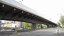
Between the two world wars, the Great West Road was built as a bypass to relieve traffic congestion in Brentford and Hounslow.
After the A30, the A4 changes its name to Bath Road, enters Cranford, and crosses the River Crane into the Borough of Hillingdon.
This bypass for the narrow main road of Colnbrook was built after the Second World War across farmland between Harmondsworth and the outskirts of Langley.
The road bends right at Taplow and passes under a high railway bridge, then over the River Thames flood prevention channel.
The A4 goes over the intersection with the A329 Cemetery Junction which links Wokingham with Pangbourne, passing the Royal Berkshire Hospital and the London Road Campus of the University of Reading.
Heading towards Thatcham, the road passes Aldermaston Wharf next to the Kennet and Avon Canal and through the villages of Woolhampton and Midgham.
At the roundabout after the industrial Estate the route follows London Road and passes Thatcham towards Benham Hill and Newbury.
This is no longer considered safe so the road now has one wider-than-normal lane in each direction, with ghost islands at junctions to discourage overtaking at these points.
The road passes underneath a covered bridge that links Morris House of Marlborough College to the North Block of the same establishment.
[19] As the route approaches the Beckhampton roundabout, which forms the intersection with the A361, it passes by the Waggon & Horses Inn, built in 1669 to profit from the increasing trade along the old Bath Road.
Heading towards the town centre, the road crosses a double mini roundabout, one exit forming the junction with the A3102 to Melksham.
On the outskirts of Chippenham is a large roundabout, where the A4 used to carry straight on down London Road and The Causeway into the town centre, which has since been pedestrianised.
The route heads downhill over the River Avon on the Avenue La Fleche, named after one of Chippenham's twin towns, to the Bridge Centre roundabout.
The route heads over Rowden Hill past the Chippenham Community Hospital and down to the spot where musician Eddie Cochran was killed in a car crash on 17 April 1960.
[24] After a series of roundabouts the A4 continues uphill, past what used to be the Ministry of Defence Naval Operations site at Copenacre (now a housing development) before descending steeply to the village of Box.
The A4 no longer has a defined route from this point to the start of Anchor Road at The Centre; originally it went along Victoria Street and Baldwin Street before turning left onto St Augustine's Parade or, later, Broad Quay, but in more recent times it followed Redcliffe Way, via Redcliffe Roundabout (junction with the A38) across Queen Square to The Centre.