Kennet and Avon Canal
The Kennet and Avon Canal has been developed as a popular heritage tourism destination for boating, canoeing, fishing, walking and cycling, and is also important for wildlife conservation.
The idea of an east-to-west waterway link across southern England was first mentioned in Elizabethan times, between 1558 and 1603,[2] to take advantage of the proximity of tributaries of the rivers Avon and Thames, only 3 miles (5 km) apart at their closest.
The small coastal sailing ships of the day were often damaged by Atlantic storms, and risked being attacked by warships of the French Navy and privateers during a succession of conflicts with France.
In 1723, despite considerable local opposition, the Kennet Navigation opened, comprising stretches of natural riverbed alternating with 11 miles (18 km) of artificially created lock cuts.
[6] In 1796, completion of the eastern end of the new canal from Newbury to Great Bedwyn was anticipated within 12 months;[6] but by July of that year, inflationary effects of the French Revolutionary Wars led labourers to take up more lucrative harvest work, and 23% of shareholders had fallen into arrears.
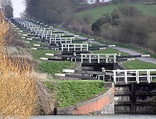
As well as Caen Hill Locks, other major structures included the Dundas and Avoncliff aqueducts, the Bruce Tunnel near Savernake Forest, and the pumping stations at Claverton and Crofton, needed to overcome water supply difficulties.
[20] During the Second World War a large number of concrete pillboxes were built as part of the GHQ Line - Blue to defend against an expected German invasion; many of these are still visible along the banks of the canal.
In July 1958, the Bowes Committee published their Inquiry into Inland Waterways which specifically mentioned the Kennet and Avon finding "no justification for restoring the section from Reading to Bath".
[26] A government white paper followed the Bowes Report in February 1959, recommending that an Inland Waterways Redevelopment Advisory Committee should assist schemes to regenerate canals that were no longer able to collect enough fees from tolls to pay for their upkeep.
[33] Various fund-raising schemes, along with some financial support from local authorities, allowed small-scale work on the locks to continue, but the projected timescales for completion were missed.
The National Association for the Care and Resettlement of Offenders sponsored a workshop, which opened in Shrivenham in 1987, to create new lock gates for the Crofton and Devizes flights.
Restoration of the turf-sided Monkey Marsh Lock proved difficult because of its status as a scheduled monument, and the consequent need to protect the historic site while improving safety.
[3] The modern Avon is navigable from its mouth at Avonmouth, through the Floating Harbour in Bristol, as far as Pulteney Weir in the centre of Bath and just beyond the start of the canal.
The stretch from Bristol to Bath is made navigable by the use of locks and weirs at Hanham, Keynsham, Swineford, Saltford, Kelston and Weston, which together overcome a rise of 30 feet (9 m) within 12 miles (19 km).
[74] The canal turns south into a valley between Bathampton Wood and Bathford Hill which includes Brown's Folly, a 99-acre (40 ha) biological and geological Site of Special Scientific Interest.
At the western end of the Dundas Aqueduct it is joined by the remains of the Somerset Coal Canal, a short stretch of which has been restored to create the Brassknocker Basin.
Between Wootton Top Lock and Crofton is the summit pound of the canal at 450 feet (140 m) above sea level, stretching for about 2 miles (3 km) and including the 502-yard-long (459 m) Bruce Tunnel.
[112] There are plans to construct a marina and hotel complex adjacent to the site, but the potential environmental impacts (particularly to water voles) of such a development on Freeman's Marsh have led to local opposition.
The SSSI includes two woods – the Wilderness and part of Ryott's Plantation – which are important because they support a very great diversity of plants associated with this woodland type, dominated by alder (Alnus glutinosa); though ash is abundant in places and there is occasional oak and wych elm.
In addition to the wide range of higher plants the woods support a diverse bryophyte flora including the uncommon epiphytes Radula complanata, Zygodon viridissimus and Orthotrichum affine.
The lower slopes are dominated by dog's mercury, with abundant herb paris, toothwort, Solomon's seal, common twayblade and early-purple orchids and, locally, wild daffodil.
[126] East of Newbury town centre the Kennet passes through the Thatcham Reed Beds a 169-acre (68 ha) Site of Special Scientific Interest, nationally important for its extensive reedbed, and species-rich alder woodland and fen habitats.
A large assemblage of breeding birds such as Cetti's warbler make use of the reedbed, fen and open water habitats found at Thatcham Reed Beds.
[127] Thatcham's network of gravel pits, reed bed, woodland, hedges and grassland is rich in wildlife and has been made into The Nature Discovery Centre by the Royal Society for the Protection of Birds.
The irregular shoreline with islands, promontories, sheltered eutrophic pools and narrow lagoons, provides undisturbed habitat for many water birds, including surface-feeding ducks such as teal and shoveler.
[134] The River Kennet itself, from near its sources west of Marlborough down to Woolhampton, has been designated as a SSSI primarily because it has an extensive range of rare plants and animals that are unique to chalk watercourses.
Under a partnership arrangement involving British Waterways, Sustrans, and the riparian local authorities, two main sections of the canal have been improved, and, with a few short diversions, run from Reading to Marsh Benham and from Devizes to Bath as part of the National Cycle Network (NCN) Route 4.
The Kennet and Avon Canal Trust operates shops and tearooms at Aldermaston Lock, Newbury Wharf, Crofton Pumping Station, Devizes, and Bradford-on-Avon.
Key sites that are home to several rare species include the Aldermaston Gravel Pits,[133] Woolhampton,[132] Thatcham Reed Beds,[127][128] and Freeman's Marsh, Hungerford.
[156][157] Measures to preserve and create water vole habitat have had considerable impact on the restoration of the canal, and new "vole-friendly" techniques of bank protection have been developed.