Battle of Cape Gloucester
1st Marine Division 65th Brigade The Battle of Cape Gloucester was fought in the Pacific theater of World War II between Japanese and Allied forces on the island of New Britain, Territory of New Guinea, between 26 December 1943 and 16 January 1944.
The western landing force acted as a diversion and cut the coastal road near Tauali to restrict Japanese freedom of movement, while the main force—landing on the eastern side—advanced north towards the airfields.
Cape Gloucester is a headland that sits on the northern peninsula at the west end of the island of New Britain, which lies to the northeast of mainland New Guinea.
It is roughly opposite to the Huon Peninsula, from which it is separated by Rooke Island with the intervening sea lane divided into the Vitiaz and Dampier Straits.
[2] The peninsula on which Cape Gloucester sits consists of a rough semi-circular coast, extending from Lagoon Point in the west to Borgen Bay in the east.
This operation was conceived with several phases, with the broad Allied scheme of maneuver being to secure all of New Britain west of the line between Gasmata and Talasea on the north coast.
[25] For the Cape Gloucester operation, US planners assigned the 1st Marine Division (Major General William H. Rupertus) which had previously fought on Guadalcanal.
[32][33] The US troops were opposed by elements of the Japanese 17th Division (Lieutenant General Yasushi Sakai), which had previously served in China before arriving on New Britain in October and November 1943.
[34][35] Matsuda's headquarters had been at Kalingi, along the coastal trail northwest of Mount Talawe, within 5 miles (8.0 km) of the Cape Gloucester airfields but after the Allied bombardment prior to the battle, it had been moved to Egaroppu, closer to Borgen Bay.
[43] For several months before the landings, the area around the airfields and the coastal plain between Cape Gloucester and Natamo, south of Borgen Bay, was bombed by Allied aircraft, mainly from the US Fifth Air Force.
[44] Meanwhile, the Allies undertook extensive aerial reconnaissance of the area, while ground teams of marines, Alamo Scouts and coastwatchers were landed at various locations except Borgen Bay over three separate occasions from PT boats between September and December 1943.
A complex was also established at the base of Mount Talawe, affording a commanding view of the airfields, which were held by a battalion of infantry supported by service troops and several artillery pieces.
[49] The Allied plan called for a two-pronged landing at several beaches to the east and west of the peninsula, followed by an advance north towards the airfields at Cape Gloucester.
Final rehearsals were carried out on 21 December after which the troops embarked on their vessels early on Christmas Day at Oro Bay and Cape Cretin, near Finschhafen.
In order to speed up the unloading process and reduce congestion on the eastern beaches, a mobile loading scheme was devised with the supplies preloaded directly on 500 2.5-ton trucks.
As they made their way towards their objective, Allied patrol boats operated to the north and western approaches, in the Dampier Strait and the southern coast of New Britain.
However, the commander of the Japanese Southeast Area Fleet, Admiral Jinichi Kusaka, incorrectly assessed that the convoy was bound for Arawe as reinforcements, and subsequently ordered a heavy air attack there instead of around Cape Gloucester with 63 Zero fighters and 25 bombers from Rabaul.
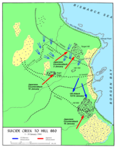
Patrol clashes increased until early morning on 30 December when the two companies of the 53rd Infantry attacked the marines around Coffin Corner, exploiting the concealment of a heavy storm and darkness to launch a concentrated assault along a narrow avenue of approach between two defended ridges.
[68] Drifting smoke from the aerial bombardment of Target Hill, obscured the beaches and the approaches, and briefly hampered the landing with some troops coming ashore in the wrong spot.
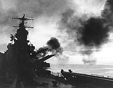
Nevertheless, around 13,000 troops and about 7,600 tons of equipment were pushed ashore during the first day of the operation on either side of the cape, and the attacking Japanese aircraft suffered losses to US fighters and ship-borne anti-aircraft fire.
[77] Amphibian landing vehicles were used to ferry ammunition forward,[78] but the volume of traffic, coupled with the heavy rain, churned up the narrow coastal road.
[84] During the final days of December, the marines overran the airfield and expanded their perimeter, incorporating Razorback Ridge, a key feature about 1,500 yards (1,400 m) to the south of No.
[62] In the weeks that followed the capture of the airfield, US troops pushed south towards Borgen Bay to extend the perimeter beyond Japanese artillery range.
This was followed by renewed fighting around Suicide Creek, as the Japanese put up a stubborn defense, which was eventually overcome with the assistance of tanks and artillery on 4 January.
Natural obstacles prevented the runway being lengthened to 6,000 feet (1,800 m) as originally planned but there were four 100-by-750-foot (30 by 229 m) alert areas, 80 hardstands, a control tower, taxiways, access roads and facilities for four squadrons.
Major General Ennis C. Whitehead, the commander of the Fifth Air Force Advanced Echelon (ADVON), decided to move the 8th Fighter Group to Nadzab and replace it with RAAF Kittyhawk squadrons from Kiriwina.
[3] Nevertheless, the airstrip played a vital role in supporting the Admiralty Islands operation commencing in February 1944 and as an emergency landing field for aircraft damaged in raids on Kavieng and Rabaul; it remained in use until April 1945.
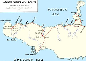
Finding it abandoned, they returned to Cape Gloucester on the 20th [103] Commencing on 23 February, the Japanese forces sought to disengage from the Americans in western New Britain and move towards the Talasea area.
[104] Mopping up operations around Cape Gloucester continued throughout early 1944, although by February 1944 the situation had stabilized enough for US planners to begin preparations to expand the lodgment further east.
In early March 1944, the Americans launched an operation to capture Talasea on the northern coast of New Britain, while following up a general Japanese withdrawal towards Cape Hoskins and Rabaul.