Siege of Fort Pulaski
Union forces on Tybee Island and naval operations conducted a 112-day siege, then captured the Confederate-held Fort Pulaski after a 30-hour bombardment.
Secretaries of War including James Monroe of Virginia, William H. Crawford of Georgia, and John C. Calhoun of South Carolina.
Following the policy of President James Buchanan and his Secretary of War John B. Floyd of Virginia, the newly inaugurated Lincoln Administration at first did not garrison and defend forts, arsenals or U.S. Treasury Mints in the South.
On January 3, 1861, 16 days before the secession of Georgia from the Union, volunteer militia seized Fort Pulaski from the Federal government[10] and, with Confederate forces, began repairing and upgrading the armament.
On November 5, General Robert E. Lee assumed command of the newly created "Department of South Carolina, Georgia and Florida", headquartering in Savannah.
Lee had earlier surveyed the fort's defenses with Colonel Olmstead and determined, "they will make it pretty warm for you here with shells, but they cannot breach your walls at that distance."
Prior to the war, the U.S. Chief of Engineers, Colonel Joseph Gilbert Totten[a] is quoted as saying of the fort, "you might as well bombard the Rocky Mountains.
[21] Lee brought Commodore Josiah Tattnall from a James River command and would employ sailors to service at a battery across from Savannah's Fort Jackson.
[24] In March, Lee passed along War Department orders to begin transferring regiments from Florida to Tennessee to reinstate operations following the "disasters to our arms" there.
The Confederate government required a withdrawal from seaboard forces into the interior of South Carolina and Georgia to better secure the breadbasket plantations feeding the armies.
[25] On Lee's transfer to Richmond, he detailed urgent defense construction, then he called on Lawton's "earnest and close attention" to the Federal's probable approach to the city.
Obstructions in the river above the city were to be set by hands provided by upriver planters in the event of an envelopment by way of Fort McAllister.
The Union naval commander, Flag Officer Samuel F. Du Pont, conducted a reconnaissance of Lee's system of defense upriver.
The Union fleet conducted explorations among the Atlantic inlets and coastal marshes by shallow draft ships, boats and monitors.
[29] At the time Pulaski was cut off from Savannah in April 1862, the garrison under the command of Colonel Charles H. Olmstead had been reduced from 650 to 385 officers and men.
The objectives were: to recapture Fort Pulaski as federal property; to close the port of Savannah to the rebels; and, to extend the blockade southward.
[33][failed verification] After building up facilities on Hilton Head Island, the Federals began preparations for besieging Fort Pulaski.
[37][38] Two days later Du Pont and Sherman made a personal reconnaissance,[15] and on 29 November, Major General Quincy Adams Gillmore, the command's chief engineering officer, with three companies of the Fourth New Hampshire, took formal possession of the entire island without opposition.
[39] The navy set the logistics train in motion, and by December 20, the army had sufficient materials for establishing "a permanent possession".
Its cargo of arms and munitions reached the entrance to Wassaw Sound at the mouth of the Savannah River on a clear night in mid November, but heavy fog in the early morning masked the ship's progress across the bar and upriver.
[31] On November 26 Tattnall's flag, CSS "Old" Savannah, in company with Resolute and Sampson sortied out from under Fort Pulaski's guns in a "brave but brief" attack on the Union ships outside the bar, driving them out to sea.
Tattnall's squadron withdrew up the Savannah River for refit and two days later, the same three resupplied the fort with six months provisions, despite "the spirited opposition of Federal ships".
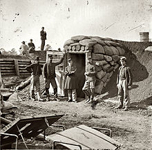
The Federal's guns had to be pulled by hand through swamp over moveable tram sections, the men working in brackish alligator-infested marsh, sinking in over their waist most of the day.
[46] At the end of February Tattnall laid plans for an amphibious assault on the two advanced batteries at Venus Point and Oakley Island.
[48] Heavy caliber rifled cannon which the Federals needed to reduce Pulaski had arrived nearby in February, at which time Gillmore decided to locate the batteries at the northwestern tip of Tybee Island nearest the fort.
The following bombardment from elevated fort guns effected mortar barrages that forced all construction to proceed on Tybee Island by night.
[50] To land the cannon onto Tybee Island, artillery pieces were taken off transports, set on rafts at high tide, and pitched into the surf near shore.
The Confederate gunnery was described by the Federal commander as "efficient and accurate firing ... great precision, not only at our batteries, but even at the individual persons passing between them.
[59] In the morning, with the wind picking up right to left and affecting shell trajectory,[60] the Union artillery resumed the bombardment, concentrating fire to enlarge the opening.
[17] Gillmore reported in his after-action assessment of the siege by his artillery, "Good rifled guns, properly served can breach rapidly" at 1600–2000 yards when they are followed by heavy round shot to knock down loosened masonry.