Battle of Valcour Island
Most of the ships in the American fleet under the command of Benedict Arnold were captured or destroyed by a British force under the overall direction of General Guy Carleton.
However, the American defense of Lake Champlain stalled British plans to reach the upper Hudson River valley.
The British fleet included four officers who later became admirals in the Royal Navy: Thomas Pringle, James Dacres, Edward Pellew, and John Schank.
The American Revolutionary War, which began in April 1775 with the Battles of Lexington and Concord, widened in September 1775 when the Continental Army embarked on an invasion of the British Province of Quebec.
The province was viewed by the Second Continental Congress as a potential avenue for British forces to attack and divide the rebellious colonies and was at the time lightly defended.
[9] Carleton then launched his own offensive intended to reach the Hudson River, whose navigable length begins south of Lake Champlain and extends down to New York City.
[11] Flowing south to north, the lake empties into the Richelieu River, where waterfalls at Saint-Jean in Quebec mark the northernmost point of navigation.
Elimination of these defenses required the transportation of troops and supplies from the British-controlled St. Lawrence Valley 90 miles (140 km) to the north.
[15] The two sides set about building fleets: the British at Saint-Jean and the Americans at the other end of the lake in Skenesborough (present-day Whitehall, New York).
While planning Quebec's defenses in 1775, General Carleton had anticipated the problem of transportation on Lake Champlain, and had requested the provisioning of prefabricated ships from Europe.
Shipwright was not a common occupation in the relative wilderness of upstate New York, and the Continental Navy had to pay extremely high wages to lure skilled craftsmen away from the coast.
[22] In addition to skilled help, materials and supplies specific to maritime use needed to be brought to Skenesborough, where the ships were constructed, or Fort Ticonderoga, where they were fitted out for use.
The process eventually came to involve General Arnold, who was an experienced ship's captain, and David Waterbury, a Connecticut militia leader with maritime experience.
Although the army leadership had been scrupulous about keeping people infected with smallpox segregated from others, the disease that slowed the shipbuilding for several weeks was some kind of fever.
At one point in August, Arnold sailed part of the fleet to the northernmost end of the lake, within 20 miles (32 km) of Saint-Jean, and formed a battle line.
[28] During his patrols of the lake Arnold had commanded the fleet from the schooner Royal Savage, carrying 12 guns and captained by David Hawley.
[29][30][31] Arnold, whose business activities before the war had included sailing ships to Europe and the West Indies, carefully chose the site where he wanted to meet the British fleet.
[33] Because his force was inferior, he chose the narrow, rocky body of water between the western shore of Lake Champlain and Valcour Island (near modern Plattsburgh, New York), where the British fleet would have difficulty bringing its superior firepower to bear, and where the inferior seamanship of his relatively unskilled sailors would have a minimal negative effect.
[35] Carleton's fleet, commanded by Captain Thomas Pringle and including 50 unarmed support vessels, sailed onto Lake Champlain on October 9.
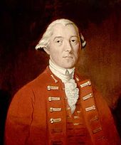
[40] The young Edward Pellew, serving as a midshipman aboard Carleton, distinguished himself by ably commanding the vessel to safety when its senior officers, including its captain, Lieutenant James Dacres, were injured.
[7] Aware that he could not defeat the British fleet, Arnold decided to try reaching the cover of Fort Crown Point, about 35 miles (56 km) to the south.
Under the cover of a dark and foggy night, the fleet, with muffled oars and minimal illumination, threaded its way through a gap about one mile (1.6 km) wide between the British ships and the western shore, where Indian campfires burned.
Arnold first decided to attempt grounding the slower gunboats at Split Rock, 18 miles (29 km) short of Crown Point.
Baron Riedesel, commanding the Hessians in Carleton's army, noted that, "If we could have begun our expedition four weeks earlier, I am satisfied that everything could have ended this year.
Apparently the letter did not cause any career problems for Pringle or its authors; he and John Schank, captain of Inflexible, became admirals, as did midshipman Pellew and Lieutenant Dacres.
[8] On December 31, 1776, one year after the Battle of Quebec, a mass was held in celebration of the British success, and Carleton threw a grand ball.
For a variety of reasons, Congress ordered an inquiry into his conduct of the Quebec campaign, which included a detailed look at his claims for compensation.
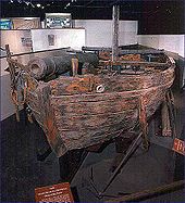
[56] In the 1930s, Lorenzo Hagglund, a veteran of World War I and a history buff, began searching the strait for remains of the battle.
Two years later it was conclusively identified as the gundalow Spitfire; this site was listed on the National Register in 2008, and it has been named as part of the U.S. government's Save America's Treasures program.