Beaver Kill
The Beaver Kill rises in western Ulster County, beginning at an elevation of 2,760 feet (840 m) just south of the col between Graham and Doubletop mountains, two of the Catskill High Peaks in the Town of Hardenburgh.
Here it turns southwest again and parallels the road through the minimally developed valley, widening slightly as it does, and receiving from the north tributaries such as Alder Creek.
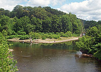
After briefly bending into Delaware County it reaches the only significant settlement along its length, the hamlet of Roscoe, where its largest tributary, Willowemoc Creek, joins it from the east at the Junction Pool, the Beaver Kill's best-known fishing hole.
Widening and turning westward again, it soon enters Delaware County and the Town of Colchester for good, passing the small hamlet of Cooks Falls shortly afterwards.
They told others of the river's clear waters and ample supply of trout, which Washington Irving wrote of in 1819, noting that its isolation kept it out of easy reach of city dwellers attracted to the new sport of angling.
The industries were prosperous enough to sustain the settlements of Beaverkill, where the oldest extant bridge over the river was constructed in 1865, and Shin Creek (today Lew Beach).
This shift to conservation helped the region sustain a new tourism economy, as rail connections, and later the automobile, brought dry-fly fishermen to the valley.
The fly-fishing community opposed this strongly, and eventually when test borings showed that the bedrock in those valleys could not support the necessary dams, the city relented.
Their efforts resulted in some slight rerouting, and a section near Cooks Falls where the two roadways were stacked on each other in a narrow passage between state Forest Preserve land and the river.