Benbecula
Benbecula's main settlement and administrative centre is Balivanich (Scottish Gaelic: Baile a' Mhanaich, meaning "Town of the Monk").
The previous landowners, a sporting syndicate, sold their 372-square-kilometre (92,000-acre) estate, which included Benbecula, South Uist and Eriskay for £4.5 million to a community-owned organisation known as Stòras Uibhist, which now manages the land in perpetuity.
[10] In common with the rest of the Western Isles, Benbecula is formed from the oldest rocks in Britain, the Lewisian gneiss which dates from the Archaean eon.
The Outer Hebrides Thrust, a legacy of the Caledonian orogeny, lies just off the eastern coast of the island and is seen on neighbouring Wiay and Marigaidh.
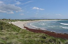
Benbecula has an extremely moderated temperate oceanic climate (Köppen: Cfb ), due to its island location.
[15] Benbecula's main settlement is Balivanich (Scottish Gaelic: Baile a' Mhanaich, meaning "Town of the Monk") in the northwest.
The township of Lionacleit houses the island's main secondary school, which also doubles as a community centre, with a swimming pool, cafeteria, sports facilities, a small museum and a library.
The RAF radar station RRH Benbecula monitors the northern Atlantic, but is located on the west coast of North Uist.
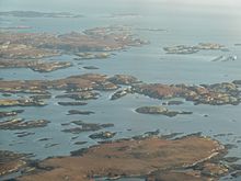
Off the east coast there are numerous small islands in Loch Uisgebhagh and beyond, including Bearran and Orasaigh Uisgeabhagh.
Further south is the larger Wiay and west from there a profusion of skerries and small islands lie to the north of Bagh nam Faoileann.
Malcolm III of Scotland acknowledged in writing that Suðreyjar was not Scottish, and king Edgar quitclaimed any residual doubts.
However, in the mid 12th century, Somerled, a Norse-Gael of uncertain origin, launched a coup, which made Suðreyjar entirely independent.
The MacRory, a branch of Somerled's heirs, ruled Benbecula, as well as Uist, Barra, Eigg, Rùm, the Rough Bounds, Bute, Arran, and northern Jura.
[20][21][22][23][24] In the 13th century, despite Edgar's quitclaim, Scottish forces attempted to conquer parts of Suðreyjar, culminating in the indecisive Battle of Largs.
[note 5] The treaty expressly preserved the status of the rulers of Suðreyjar; the MacRory lands, excepting Bute, Arran, and Jura, became the Lordship of Garmoran, a quasi-independent crown dependency, rather than an intrinsic part of Scotland.
At the turn of the century, William I had created the position of Sheriff of Inverness, to be responsible for the Scottish highlands, which theoretically now extended to Garmoran.
Nevertheless, following his usurpation, the Skye sheriffdom ceased to be mentioned,[note 6] and the Garmoran lordship (including Uist) was confirmed to the MacRury leader.
[30] As Alexander had by now inherited Godfrey's de facto position as Lord of Garmoran, and in view of Ranald's heirs being no less responsible for the violence, King James declared the Lordship forfeit.
Following the forfeiture, most of Garmoran (including Benbecula) remained with the Scottish crown until 1469, when James III granted Lairdship of it to John of Ross, the Lord of the Isles.
Hugh died a few years later, in 1498, and for reasons that are not remotely clear, his son John of Sleat immediately resigned, transferring all authority to the king.
[36] In 1596, concerned by the active involvement of Highland leaders in Irish rebellions against Queen Elizabeth of England, King James VI of Scotland (Elizabeth's heir) demanded that Highland leaders send well-armed men, as well as attending themselves, to meet him at Dumbarton on 1 August, and produce the charters for their land.
In 1622, however, his successor, Donald Gorm Og,[note 17] is found requesting that the Privy Council physically punish the Clan Ranald leadership for not removing their families and tenants from Benbecula;[38] presumably they had not been paying the rent.
[39] In 1633, Donald Gorm Og decided to sell the lairdship of Benbecula to the Earl of Argyll;[note 18] in January 1634, this arrangement was confirmed by a Crown charter.
[40] In 1661, as a leading opponent of king Charles I, the Earl's son – the Marquess of Argyll – was convicted of high treason, and his lands became forfeit.
Despite mainly being Presbyterian, Flora and the population of Benbecula were sympathetic to the Jacobite cause, and the Prince and his companions received hospitable treatment.
She disguised him as an Irish spinning maid, Betty Burke, and by this means smuggled him off the island, on 27 June, and took him "over the sea to Skye".
Already accustomed to treating people as slaves, and seeing the financial advantages to livestock farming, Gordon was ruthless, evicting the population with short notice, sometimes even resorting to dragging them to the shore in handcuffs, wearing little more than their undergarments.
The previous landowners, a sporting syndicate, sold the assets of the 372-square-kilometre (92,000-acre) estate including Benbecula, South Uist and Eriskay for £4.5 million to a community-owned organisation known as Stòras Uibhist which was set up to purchase the land and to manage it in perpetuity.