Benguet
The mountainous area now covered by Benguet is generally presumed to have been settled from at least the 14th century by tribes coming from the surrounding lowlands, lured by the abundance of natural resources such as gold, hides, and wax.
In the pre-conquest period, these tribes enjoyed flourishing trade with lowland groups immediately to their west and south, such as the Pangasinans.
The economy of the region was based on rice terraces, root crop swidden farming, livestock raising, hunting, foraging, plus the mining and trading of gold.
[7][8]: 183 At the beginning of the Spanish Era, colonisers heard of the rich gold mines in the mountains and attempted to colonize the highlands, but failed.
In 1572, Spanish conquistador Juan de Salcedo led a small expedition into the southern part of Benguet, but the natives forced it to retreat.
This brought jobs, and many lowlanders migrated to Benguet, especially in towns surrounding the gold mines, such as Itogon, Mankayan and Tuba.
[6][18][19] On June 22, 1973, as part of the Integrated Organization Plan of President Ferdinand Marcos, Benguet was placed under the jurisdiction of the Ilocos Region.
[20] When the Cordillera Administrative Region was established by President Corazon Aquino through Executive Order 220 on July 15, 1987, Benguet was made one of its provinces.
The Zigzag is composed of deep depositional environment interbedded green sandstones, red siltstones, oligomicitc conglomerates, and minor limestone units.
The Middle-Late Miocene Klondyke Formation was deposited during Central Cordillera geologic uplift, consisting of coarse clastics, polymictic conglomerates, sandstones, and vitric (glassy) tuffs, with minor shales and siltstones.
Gold mineralization occurred with dioritic and gabbroic intrusions, and basaltic to andesitic lavas, including the Monglo adakite.
[23] The main gold base metal mineralization zone is approximately 8 km wide, trends north south for tens of kilometers, and is centrally located at 16° 20' to 16° 26' N latitude and 120° 37' 30" to 120° 43' 30" E longitude.
[24][25][8] Benguet covers an area of 2,769.08 square kilometres (1,069.15 sq mi) occupying the southwestern tip of the Cordillera Administrative Region.
If Baguio is included for geographical purposes, the total area of Benguet is 2,826.59 square kilometres (1,091.35 sq mi).
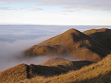
The mountains form the headwaters of several rivers, the major ones which include the Agno, Amburayan, Bued, Bakun, Balili and the Asin.
Most of Benguet falls under the subtropical highland climate (Köppen Cwb) zone, experiencing annual average highs of 25.3 °C (77.5 °F) in April and lows of 13.3 °C (55.9 °F) in January.
[28] The province suffers from crop damage resulting from seasonal frost during the cold months of December to March, especially in high-altitude towns such as Atok, Buguias, Mankayan and Kibungan.
[26] The highly urbanized city of Baguio, although administratively independent from Benguet, is situated in the interior of the province, surrounded by the municipalities of La Trinidad, Itogon, Sablan and Tuba.
The 13 municipalities of the province comprise a total of 140 barangays, with Pico in La Trinidad as the most populous in 2010, and Anchokey in Kabayan as the least.
This figure is up by 16,296 from 313,833 persons recorded in the 1995 census, giving an annual growth rate of 1.09% during the 5-year period compared to the national average of 2.43%.
Ilokano population particularly doctors, teachers, businessmen and public servants arrived during the American period for the improvement of the health condition and for the education of the people.
The pioneer Ilocanos helped establish La Trinidad as a commercial and political center.This resulted in an improved healthcare, education and economic life of the people' lives.
[36] Benguet residents generally speak their own languages in addition to Ilocano, Tagalog, and English, which are used for trade and commerce.
[54] Major crops produced which include potatoes, Baguio beans, peas, strawberries, cabbage, broccoli, cauliflower, lettuce, sayote and carrots are shipped throughout the country.
[63][64] Other agricultural-related activities are monggo processing, fruit preservation, peanut brittle manufacturing, broom making and basket weaving.
[6] The Benguet Corporation, the first and oldest mining company in the Philippines, has extracted gold, copper and chromite in Itogon since 1903.