Berrick Salome
Berrick Salome /ˈbɛrɪk ˈsæləm/[1] is a village and civil parish in South Oxfordshire, England, about 3 miles (5 km) north of Wallingford.
His study, which was published in 1968 as The Departed Village: Berrick Salome at the Turn of the Century, also included an introduction to local history.
This provided much of the information for "A Village History" which appeared in The Berrick and Roke Millennium Book[3] and is the major source for this article.
[8] The most significant of these springs rises near Grove Barn, and is the source of the brook which enters the village along Hollandtide Bottom and flows, culverted in places, past the village pond (which it does not feed) before turning south to run under the forecourt of the Chequers Inn, under the road and across fields, passing east of Lower Berrick Farm and then turning west toward the Thames.
He also notes that, as late as the 1960s, a resident of Berrick Littleworth could be seen crossing Back Street to draw water from a roadside brook flowing from Hillpit Spring.
Christine Holmes, in Benson: A Village Through its History identifies a "straight Roman road running east from Dorchester along which the churches of Shirburn, Pyrton, Cuxham, Brightwell Baldwin, Berrick Salome and Warborough all lie".
It has been suggested that, when St Helen's was built, there may have been houses grouped around the church,[10] and that the village centre may have moved later to the junction where the track along Hollandtide Bottom meets routes to Chalgrove, Newington, Warborough, and Benson.
It is uncertain when the church was first established in Berrick but the fact that it is dedicated to Saint Helen suggests that it may have been founded (or refounded) in the late eighth century when King Offa of Mercia recaptured the Benson area from Wessex.
[20] Perhaps the college preferred not to give control to the then Rector of Berrick, the radical Robert French Laurence, for fear that he would use the land to house the poor.
[14] Sherwood and Pevsner commend the medieval tiles found in the chancel[15] as one of the more notable collections in the county, along with those at Nuffield and Somerton.
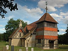
[25] "A photograph of Saint Helen's taken just before the restoration in 1890 shows it had then merely been faced with simple weather-boarding carried nearly to the top, where, as now, horizontal apertures were contrived to release the sound of the bells.
The Builder magazine criticised the restoration, saying that it "exceeded real necessity",[21] and it was condemned by Sherwood and Pevsner as "a hideous application of all the trappings of fashionable late [19th century] domestic architecture to a church.
[28] The Domesday Book values Berewiche (Berrick) at £5 a year, compared with £30 and £15 respectively for the neighbouring parishes of Bensingtone (Benson) and Neutone (Newington).
"Villeins typically held land of their own in the village fields, but conditional on payment of dues and provision of labour to the lord of the Manor, while bordari [bordars or cottars] usually held smaller holdings, or cottages and surrounding plots only and owed heavy labour services obliging them to work on the lord's demesne",[31] and serfs, the lowest category, although they could not be sold as individuals, could be transferred with the land which they worked.
[31] The northern boundary was set in the early 11th century when a manor, bounded to the south by Hollandtide Bottom, was forfeited to King Canute.
[37] The village boundaries seem to have developed haphazardly from the earliest times and remained complicated even after the Divided Parishes and Poor Law Amendment Act 1882 which, locally, resolved only the position of some distant water meadows and invasive parts of Benson.
[40] Only the western boundary was relatively simple, but even there, the parish had once included water meadows on the River Thame, south-west of Newington and about 2 miles (3 km) from Berrick.
[41] Within the boundaries, there were, in the centre of Berrick, midway between the Chequers and the southern fork, two houses and some plots of land which were detached parts of Benson parish.
[42] St Helen's parish church is the only significant building and, as the Rev George Villiers A.M., rector from 1722 to 1748, reported to a diocesan visitation in 1738, "there is no family of note".
This must have affected nearly half the households in Berrick Salome, but Moreau found no impression that the change had disrupted village life.
The first was the allotment of 3 acres, 2 roods and 25 poles (about 1.5 hectares) "unto the Churchwardens and Overseers of the Poor" of Berrick Salome "to be held by them and their successors in trust as a place for exercise and recreation for the inhabitants.
Another, and less welcome, feature of the Award was the declaration of several dozen traditional roads, ways and tracks (mainly crossing common land) as 'discontinued and stopped'.
[54] Writing a century after the Award, Moreau found that resentment of the closure of Keame's Hedge Way was still remembered, and he records that there had been an unsuccessful attempt to keep it open by the curious device of carrying a corpse along the track.
Robert French Laurence (1807–85), who was vicar of Chalgrove and Berrick Salome for the last 53 years of his life,[58] was secretary of the local agricultural workers' trades union.
Moreau records that boots for that purpose were provided[59] out of Mary White's bequest, a small charitable income left in 1729, to teach reading to the children of the poor in Berrick.
[citation needed] Moreau recorded five licensed premises selling mainly beer to a local population of about 300 at the turn of the century.
[65] However, the rapid spread of mechanisation, beginning with the appearance of the first tractors shortly before the First World War, brought about a steady decline in the number of farm labourers.
Alison Reid writes "By 1930, the Morris car factories at Cowley, reached by bicycle and later by works bus, attracted workers from places as distant as Benson".
Another casualty of the same era was the garage at Woodbine Cottage in Roke, generally remembered only for a single derelict petrol pump that was removed in the 1980s.
Janette Baker, now living in Rokemarsh, grew up in Roke, in the bungalow next door to Woodbine Cottage, and recalls passing "the garage" on her way home from the school bus.