Beyoğlu
[1] It is on the European side of Istanbul, Turkey, separated from the old city (historic peninsula of Constantinople) by the Golden Horn.
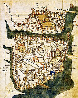
It was known as the region of Pera (Πέρα, meaning "Beyond" in Greek) surrounding the ancient coastal town Galata which faced Constantinople across the Horn.
[4] His son Alvise Gritti, who had close relations with the Sublime Porte, also stayed there and was probably the person who was specifically referred to as Bey Oğlu after his father became the Doge of Venice.
[5] Once a predominantly Christian (Armenians, Greeks, and Turkish Levantine) neighbourhood,[6][7] its population today mostly consists of Turks and Kurds who moved there after the Republic of Turkey was founded in 1923 and after the Istanbul pogrom in 1955.
Venice immediately established political and commercial ties with the Ottoman Empire, and a Venetian Bailo was sent to Pera as an ambassador, during the Byzantine period.
During the 19th century it was again home to many European traders,[citation needed] and housed many embassies,[13] especially along the Grande Rue de Péra (today İstiklâl Avenue).
[citation needed] Reyhan Zetler stated "Pera was considered to be a small copy of the [sic] 19th century Europe (especially Paris and London).
"[13] The presence of such a prominent European population - commonly referred to as Levantines - made it the most Westernized part of Constantinople, especially when compared to the Old City at the other side of the Golden Horn, and allowed for influxes of modern technology, fashion, and arts.
Thus, Pera was one of the first parts of Constantinople to have telephone lines, electricity, trams, municipal government and even an underground railway, the Tünel, inaugurated in 1875 as the world's second subway line (after London's Underground) to carry the people of Pera up and down from the port of Galata and the nearby business and banking district of Karaköy, where the Bankalar Caddesi (Avenue of the Banks), the financial center of the Ottoman Empire, is located.
The theatre, cinema, patisserie and café culture that still remains strong in Beyoğlu dates from this late Ottoman period.
Pera and Galata in the late 19th and early 20th centuries were a part of the Municipality of the Sixth Circle (French: Municipalité du VIème Cercle), established under the laws of 11 Jumada al-Thani (Djem.
The rapid modernization which took place in Europe and left Ottoman Turkey behind was symbolized by the differences between Beyoğlu, and the historic Turkish quarters such as Eminönü and Fatih across the Golden Horn, in the Old City.
When the Ottoman Empire collapsed and the Turkish Republic was founded (during and after the First World War) Pera, which became known as Beyoğlu in English in the modern era, went into gradual decline.
The decline accelerated with the departure of the large Greek population of Beyoğlu and adjacent Galata as a result of Turkish pressure over the Cyprus conflict, during the 1950s and 1960s.
The widespread political violence between leftist and rightist groups which troubled Turkey in the late 1970s also severely affected the lifestyle of the district, and accelerated its decline with the flight of the middle-class citizens to newer suburban areas such as Levent and Yeşilköy.
[citation needed] As newer, more international and affluent residents have begun to creep down the hills into Tophane and Tarlabasi, disagreements with more conservative elements in the neighborhoods have become common.
[citation needed] Parallel to İstiklal Avenue runs the wide bi-directional boulevard named Tarlabaşı Caddesi, which carries most of the traffic through the area and was constructed in the 1980s.
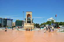
[16] The main thoroughfare is İstiklâl Caddesi, running into the neighbourhood from Taksim Square, a pedestrianised 1 mile (1.6 km) long street of shops, cafés, patisseries, restaurants, pubs, winehouses and clubs, as well as bookshops, theatres, cinemas and art galleries.
The nostalgic tram which runs on İstiklal Avenue, between Taksim Square and Tünel, was also re-installed in the early 1990s with the aim of reviving the historic atmosphere of the district.
The 19th century Çiçek Pasajı (literally Flower Passage in Turkish, or Cité de Péra in French, opened in 1876) on İstiklal Avenue can be described as a miniature version of the famous Galleria in Milan, Italy, and has rows of historic pubs, winehouses and restaurants.
[17][18][19] The theatre was frequently visited by Sultans Abdülaziz and Abdülhamid II, and hosted Giuseppe Verdi's play Il Trovatore before the opera houses of Paris.
Some historic neighbourhoods around İstiklal Avenue have recently been recreated, such as Cezayir Street near Galatasaray High School, which became known as La Rue Française and has rows of francophone pubs, cafés and restaurants playing live French music.
Beyoğlu also has many elegant pasaj (passages) from the 19th century, most of which have historic and classy chocolateries and patisseries along with many shops lining their alleys.
Istanbul Modern, located near Karaköy Port on the Bosphorus, frequently hosts the exhibitions of renowned Turkish and foreign artists.
Pera Museum exhibits some of the works of art from the late Ottoman period, such as the Kaplumbağa Terbiyecisi (Turtle Trainer) by Osman Hamdi Bey.
The famous street with shops, cafes, cinemas and other venues stretches for 1.4 kilometres (0.87 mi) and hosts up to 3 million people each day.