Bibracte
It is the focus of cooperative European archaeological efforts, a training ground for young archaeologists, and a centre for interpreting Gaulish culture for a popular audience.
Before the Roman conquest in 52 BC the great Celtic city of Bibracte had more than thirty thousand inhabitants,[1] protected by a huge stone wall of the Murus Gallicus type which enclosed an area of 135 hectares.
Some scholars of the era have cited other evidence to justify placing the Aeduian oppidum on the site of Autun (the former Augustodunum), which was effectively the capital of the Aedui in the first century.
The publication of his Essay on the Roman System of Defense in the Aedui country between the Saône and the Loire, in which he revealed his convictions, was not taken seriously by the members of the Society of Archeology.
Interested by these investigations, the Archbishop shared the various findings with the Emperor who, in 1867, assigned Bulliot to do research at Mont Beavray and funded his work.
His nephew Joseph Déchelette, whom he introduced to excavation, continued the work until 1907, comparing Bibracte to other sites in Europe such as Stradonice in Bohemia, the Manching in Germany and Velem-Zenst-Vid in Hungary, which were precursors of the cultural unification of the Celtic world and of the civilization of oppida.
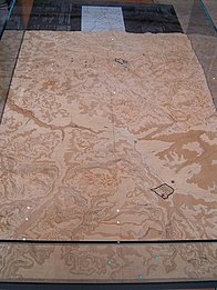
[9] Dating techniques have shown that the oppidum was founded at end of the 3rd century BCE, on an area of 200 hectares protected by the exterior rampart.
This privileged status prevented Bibracte from suffering much from conflict: in 58 BCE, at Montmort 25 kilometers south of the site, Julius Caesar's armies defeated the Helvetii,[11] forcing them to return to Switzerland and gradually be incorporated into what became the Roman Empire.
Migration could have been caused by economic reasons or by a desire to integrate with the Roman model; a part of the dominant Aedui class, already pro-Roman during the Gallic War, definitely realized the strategic importance of the new city located on the principal axes of communication and wanted to conform to the Roman model of flatland cities, while a more traditional population remained for a time on the Bibracte site.
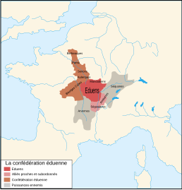
Moreover, they maintained commercial links and military alliances: Rome helped the Aedui in the 2nd century to defeat an Arverni army and rose to their defense against the invasion of the Helvetii that precipitated the Gallic War.
Gabriel de Mortillet, in his classification of ancient peoples, included the site's residents under the name "Beavraisian", a category abandoned by modern scholars.
In addition, the Aedui installed a system of customs that taxed products passing through their territory to increase their wealth, as attested in the texts of Julius Caesar: "It was typical of Dumnorix: the man was audacious, his generosity made him popular, and he wanted political change.
In the centre of the oppidum many cellars and certain public buildings that stored large quantities of cereals and wine imported from the southern countries have been found.
From 1865 to 1895, Gabriel Bulliot identified Bibracte in 1867 and began excavations there (notably the Celtic artisanal neighborhood surrounding the Rebout gate), with the aid of funds allocated by Napoleon III.
The label of "national interest" was created afterward in order to designate exhibitions or sites which benefit from a program of diffusion and enlargement of the public by the Minister of Culture.
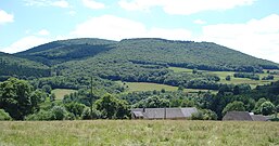
Aerial and electromagnetic prospecting is made impossible by the forest and vegetation on the mountain since the end of grazing and the excavations of Joseph Déchelette, as well as the nature of the subsoil.
[25] One costly but faster technique, tested in 2007, is LIDAR, the use of airborne laser scanners, which are unhindered by the vegetation and can recreate in minutes what usually takes weeks to do on the ground.
This organization differs from that of oppida like Manching, where there is a regular urban framework; this is explained by the relief of the terrain, as the battlements encircle three summits with some relatively steep slopes.
In the first phase of construction (c. 70 BC) a terrace was built, surrounded by a murus gallicus stone wall with a large entrance on the east side.
[30] Excavations on the site of Beuvray, in the region of the Champlain, and on the surrounding massifs revealed the existence of mines for the extraction of metals, including gold, iron, and tin ore.
Another artisanal neighborhood has been found in the region of one of the summits of the site, at the Rock of the Wyvern, an area which had been little investigated at the time of Bulliot and Déchelette's research.
In fact, it developed from a wood construction (of Roman inspiration) into a domus with an atrium containing an impluvium, porticos, and thermae heated by hypocaust, along with a system of sewers.
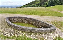
[31] At the centre of the main road, in the area of the Pasture of the Monastery, stands a pink granite monumental basin which is thought to have had a sacred function.
[38][39] Maumené (2018) suggests that the main axis of the basin is orientated towards a celestial alignment with the constellation of Gemini, reflecting the religious importance of the Dioscuri (Divine Twins) in the Gallic pantheon.
Besides this, they have many discussions as touching the stars and their movement, the size of the universe and of the earth, the order of nature, the strength and the powers of the immortal gods, and hand down their lore to the young men.”[52]The later Aeduan capital of Augustodunum [fr] was the location of the Menian schools, which were dedicated to the study of liberal arts and law.
In the area of the Convent Pasture the excavations revealed, under a large domus of the Augustan era, the presence of an exceptional public monument, which was at the time unique in Gaul: a Roman basilica with three naves and an internal peristyle with a peripheral ambulatory, displaying four rows of eight columns or eight pilasters.
It was connected on the east with a small square, 22 meters on a side, bordered to the north and south with porticos which were extensions of the walls of the annexes of the basilica.
At this date, the basilica and the square were carefully leveled and replaced by a large private residence, doubtless in connection with the move of the Aedui capital to Autun.
The basilica of Bibracte confirms the exceptional importance of the site and revealed that the Romanization of the Aedui was considerably more rapid than previously believed.
One of the facades, which are large picture windows, is hidden by a wall of stone (on the valley side), while that which faces the site allows free view to the visitors.