Biome
A biome (/ˈbaɪ.oʊm/) is a distinct geographical region with specific climate, vegetation, and animal life.
[5] In the Brazilian literature, the term biome is sometimes used as a synonym of biogeographic province, an area based on species composition (the term floristic province being used when plant species are considered), or also as synonym of the "morphoclimatic and phytogeographical domain" of Ab'Sáber, a geographic space with subcontinental dimensions, with the predominance of similar geomorphologic and climatic characteristics, and of a certain vegetation form.
[6][7][8] To divide the world into a few ecological zones is difficult, notably because of the small-scale variations that exist everywhere on earth and because of the gradual changeover from one biome to the other.
[9] A 1978 study on North American grasslands[10] found a positive logistic correlation between evapotranspiration in mm/yr and above-ground net primary production in g/m2/yr.
The general results from the study were that precipitation and water use led to above-ground primary production, while solar irradiation and temperature lead to below-ground primary production (roots), and temperature and water lead to cool and warm season growth habit.
[15] Whittaker used what he called "gradient analysis" of ecocline patterns to relate communities to climate on a worldwide scale.
The multi-authored series Ecosystems of the World, edited by David W. Goodall, provides a comprehensive coverage of the major "ecosystem types or biomes" on Earth:[17] The eponymously named Heinrich Walter classification scheme considers the seasonality of temperature and precipitation.
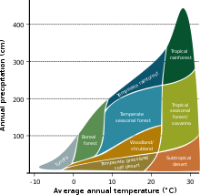
The boundaries of each biome correlate to the conditions of moisture and cold stress that are strong determinants of plant form, and therefore the vegetation that defines the region.
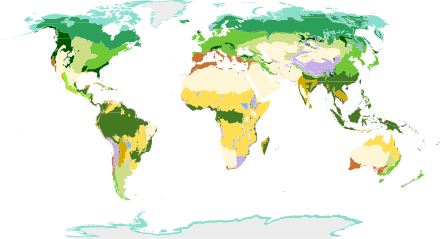
A team of biologists convened by the World Wildlife Fund (WWF) developed a scheme that divided the world's land area into biogeographic realms (called "ecozones" in a BBC scheme), and these into ecoregions (Olson & Dinerstein, 1998, etc.).
As a result, vegetation forms predicted by conventional biome systems can no longer be observed across much of Earth's land surface as they have been replaced by crops and rangelands or cities.
[43][44] With its annual average temperature continuing to increase, the moisture currently located in forest biomes will dry up.