Biscay
Biscay is one of the most renowned and prosperous provinces of Spain, historically a major trading hub in the Atlantic Ocean since medieval times and, later on, one of the largest industrial and financial centers of the Iberian Peninsula.
Later, in the 19th and 20th centuries, the abundance of prime quality iron ore and the lack of feudal castes favored rapid industrialization.
Mousterian artifacts have been found in three sites in Biscay: Benta Laperra (Karrantza), Kurtzia (Getxo) and Murua (Durangoaldea).
Tools become smaller and more refined and, while hunting remains, fishing and seafood gathering become more important; there is evidence of consumption of wild fruits as well.
While the first evidences of Neolithic contact in the Basque Country can be dated to the 4th millennium BCE, it was not until the beginning of the 3rd that the area accepted, gradually and without radical changes, the advances of agricultural cultivation and domestication of sheep.
Biscay was not particularly affected by this change and only three sites can be mentioned for this period: Arenaza, Santimamiñe and Kobeaga (Ea) and the advances adopted seem limited initially to sheep, domestic goats and very scarce pottery.
While open-air settlement started to become common as the population grew, they still used caves and natural shelters in Biscay in the Chalcolithic and Bronze Age.
The Caristii dwelt in nuclear Biscay, east of the firth of Bilbao, extending also into Northern Araba and some areas of Gipuzkoa, up to the river Deba.
The Autrigones dwelt in the westernmost part of Biscay and Araba, extending also into the provinces of Cantabria, Burgos and La Rioja.
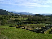
The site of Forua, near Gernika, has yielded archaeological evidence of Roman presence [1] Archived 12 March 2007 at the Wayback Machine.
The Visigoths established an outlying post at the later city of Vitoria to counter incursions and the migration of Basques from the coastal regions to the north.
In 905, Leonese chronicles define for the first time the Kingdom of Pamplona as including all the western Basque provinces, as well as the Rioja region.
These pro-Castilian lords were led by the house of Haro, who were eventually granted the rule of newly created Biscay, initially made up of the valleys of Uribe, Busturia, Markina, Zornotza and Arratia, plus several towns and the city of Urduina.
Along with other Basque towns of Gipuzkoa and Labourd, they were largely responsible for the partial extinction of North Atlantic right whales in the Bay of Biscay and of the first unstable settlement by Europeans in Newfoundland.
[citation needed] After the Napoleonic wars, Biscay, along with the other Basque provinces, were threatened to have their self-rule cut by the now Liberal Spanish Cortes.
Together with opposing factions that supported different parties for the throne, this desire to maintain foral rights contributed to the successive Carlist Wars.
The Biscayan government and other Basque provinces supported Carlos V, who represented an autocratic monarch who would preserve tradition.
In the end, with victory by anti-Carlists, the wars resulted in successive cuts of the wide autonomy held by Biscay and the other provinces.
When the Spanish Civil War broke out in 1936, Biscay supported the Republican side against Francisco Franco's army and ideology.
Due to fascist control of large parts of it, the first short-lived Basque Autonomous Community had power only over Biscay and a few nearby villages.
As the fascist army advanced westward from Navarre, defenses were planned and erected around Bilbao, called the Iron Belt.
In 1937, German airplanes under Franco's control destroyed the historic city of Gernika, after having bombed Durango with less severity a few weeks before.
Under the dictatorship of Franco, Biscay and Gipuzkoa (exclusively) were declared "traitor provinces" because of their opposition and stripped of any sort of self-rule.
During this recent democratic period, Basque Nationalist Party candidates have consistently won elections in Biscay.
[10] The main geographical features of the province are: Historically, Biscay was divided into merindades (called eskualdeak in Basque), which were two, the Constituent ones and the ones incorporated later.
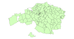
The constituent ones were (the number indicates their position on the map): Incorporated later: Currently, Biscay is divided into seven comarcas or regions, each one with its own capital city, subdivisions and municipalities.
It connects Bilbao and its neighborhoods with other municipalities and regions inside Biscay, like Barakaldo, Santurtzi, Portugalete, Muskiz, Orduña and others.