Urkiola
It was declared natural park on 29 December 1989 prompted by the Basque government's determination to protect the diversity of wildlife and flora it harbours.
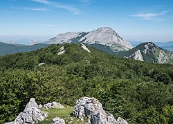
It is formed by several limestone massifs, from west to east: At this point of the range the Urkiolamendi pass breaks through it at a height of 711 m, where a sanctuary was built.
The closeness to Bilbao and easy access through Urkiolamendi pass attract many tourists and hikers all year round.
In Mañaria archaeologist have found a lot of evidence that Visigoths used to live in that part of the mountain range.
One of the most important pieces of evidence of that is a letter from the king of Pamplona Nájera Gárcia Sánchez who says that the churches of Durango are allowed.