Black Mountains, United Kingdom
The Black Mountains (Welsh: Y Mynydd Du or sometimes Y Mynyddoedd Duon) are a group of hills spread across parts of Powys and Monmouthshire in southeast Wales, and extending across the England–Wales border into Herefordshire.
They are the easternmost of the four ranges of hills that comprise the Brecon Beacons (or Bannau Brycheiniog) national park, and are frequently confused with the westernmost, which is known as the Black Mountain.
In his description of a Blak Montayne, the antiquarian John Leland refers to a massif extending between Carmarthen and Monmouth i.e. what is now considered to be the Brecon Beacons in the wider modern sense of that term, thus including the Black Mountain far to the west and the intervening high ground.
There is a suggestion too that the names Hatterrall Hill and Mynydd y Gader may also once have been used to apply to the entire range of the Black Mountains though the former later became confined to the vicinity of its eastern ridge.
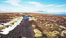
[3] The highest mountain in the group is Waun Fach whose heavily eroded peat summit plateau attains a height of 811 metres (2,661 ft).
On the eastern ridge, the 703 metres (2,306 ft) peak of Black Mountain stands on the Wales-England border, and is the highest point in England south of Great Whernside in Yorkshire.
This thick sedimentary sequence is largely terrestrial in origin, comprising a range of alluvial sediments from conglomerates and sandstones to mudstones and siltstones and includes a few thin secondary limestones.
The exception is the summit area of Pen Cerrig-calch where a thin sequence of Carboniferous rocks occur, an outlier of the more extensive outcrop to the south of the Usk valley.
[7] The Usk valley glacier wrapped around the southern margin of the massif, forming another couple of piedmont lobes south and east of Abergavenny.
[9] Several have been recorded in the Vale of Ewyas, including that at Darren and the active one at Cwmyoy which continues to slowly distort St Martin's Church.
[10] Further landslips have occurred at Black Darren and Red Daren ('tarren' signifies 'edge' in Welsh) on the eastern side of the Hatterrall ridge west of Longtown.
[11] Scattered around the range are innumerable small quarries, virtually all of which now lie abandoned, once a source of walling and roofing stone for local use.
The Offa's Dyke National Trail runs along the border between England and Wales, whilst the Beacons Way, Cambrian Way and Marches Way also pass through the Black Mountains.
Antiquities include Llanthony Priory in the Vale of Ewyas, ruined Craswall Priory, Tretower Castle, Tretower Court, the Iron Age hill fort of Crug Hywel, and the remains of Castell Dinas, an 11th to 13th century castle built on the site of an Iron Age hillfort between Talgarth and Crickhowell.
Settlements in and around the Black Mountains include Hay-on-Wye, Llangors, Talgarth, Crickhowell, Cwmdu, each in Powys, Abergavenny in Monmouthshire and Longtown in Herefordshire.