Black Rock Desert
[2] The region is notable for its paleogeologic features, as an area of 19th-century Emigrant Trails to California, as a venue for rocketry, and as an alternative to the Bonneville Salt Flats in northwestern Utah for setting land speed records (Mach 1.02 in 1997).
[6] At its base is a large hot spring and grassy meadow, which was an important place for those crossing the desert headed for California and Oregon.
In 1843, John Frémont and his party were the first white men to cross the desert, and his trail was used by over half of the 22,000 gold seekers headed to California after 1849.
The playa extends for approximately 100 mi (160 km) northeast from the towns of Gerlach and Empire, between the Jackson Mountains to the east and the Calico Hills to the west.
If the playa is wet for a month or so, then the shallow waters teem with fairy shrimp, or anostraca born of eggs that lie dormant in the silt crust for long periods of time—sometimes for many years.
The playa of the Black Rock Desert lakebed is ~200 sq mi (520 km2) within an area bounded by the Calico Mountains Wilderness (north), Gerlach (west), the Applegate National Historic Trail (northeast), and the Union Pacific Railroad (south).
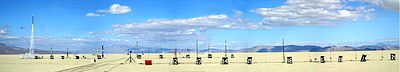
The flatness of the Black Rock Desert's lakebed surface has led to the area's use as a proving ground for experimental land vehicles.
In May 1999, JP Aerospace used a rockoon (balloon-launched rocket) in an unsuccessful suborbital space flight attempt covered by CNN.
[59] On September 21, 2013, the University of Southern California's Rocket Propulsion Laboratory (USCRPL) launched its first space shot attempt, Traveler, intended to achieve a max altitude of 75 miles (121 km).
If successful, Traveler would have been the first university/student-designed and built rocket to exceed the 62.14-mile (100.00 km) Kármán line required to claim a space flight.
Great Basin tribes inhabited the area approximately 10,000 B.P.,[3] and a Frémont Expedition encountered the site in 1843, but the Fortieth Parallel Survey (1867) conducted the first official exploration.
Guru Road, located about 2 miles north of Gerlach on Highway 34, consists of a series of art installations that include aphorisms and the names of local residents carved in to rocks.
Larger installations such as "Ground Zero", Elvis, Imagination Station – Desert Broadcasting System (where the windows are TV frames with different panoramas) are also present.
In 2010, the Bureau of Land Management Winnemucca District Office completed a roundup of 1,922 wild horses in the Calico Mountains Complex, of which 39 died of malnutrition due to overgrazing.
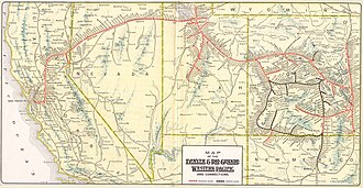
[80] The Union Pacific Railroad Elko Subdivision runs along the lakebed's east side between Sulphur and Gerlach.
Light aircraft have landed on the lakebed for events (the nearby Empire and Reno-Tahoe International Airports provide commercial service for the area).