Blakeney Chapel
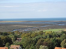
The building stood on a raised mound or "eye" on the seaward end of the coastal marshes, less than 200 m (220 yd) from the sea and just to the north of the current channel of the River Glaven where it turns to run parallel to the shoreline.
The surviving ruins are protected as a scheduled monument and Grade II listed building because of their historical importance, but there is no active management.
[1] The Eye is a sandy mound in the marshes that is located inside the sea wall at the point where the River Glaven turns westward towards the sheltered inlet of Blakeney Haven.
[4][5] These listings do not cover the land around them, but the whole of the marsh forms part of the 7,700-hectare (19,000-acre) North Norfolk Coast Site of Special Scientific Interest (SSSI) because of its internationally important wildlife value.
[6][7] The building was first shown on a 1586 map of the Blakeney and Cley area, apparently drawn to be used in evidence in a legal case regarding the rights to "wreck and salvage", the outcome of which is unknown.
Some maps, including Faden's, show a second ruined chapel across the Glaven on Cley Eye, but no other documentation exists for that building.
[10][11] An anonymous booklet on Blakeney published in 1929 states that there was a "chapel of ease" on the marshes, served by a friar from the Convent, but the document on which this seems to be based, a Calendar of Patent Rolls dated 20 April 1343, simply notes that a local hermit was given permission to seek alms in "divers parts of the realms".
This survey was conducted under a licence from English Heritage that allowed access but did not permit excavation, so it relied on height measurements, geophysics (resistivity, and magnetometry) and molehill sampling.
The magnetometry failed to detect the subterranean features of the chapel, but did show an unexpected linear anomaly, related to buried ironwork from wartime defences.
The resistivity survey clearly showed the larger room, but barely detected the smaller, suggesting that it had less substantial foundations, was probably less well-constructed, and possibly later in date.
[1] Plans for a realignment of the Glaven channel meant that the Eye would be left unprotected to the north of the river, and would eventually be destroyed by coastal change.
It was decided that the only practical course of action was to investigate the site while it still existed, and a preliminary evaluation was carried out in 2003 in preparation for a full survey in 2004–05.
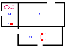
[13] The earliest evidence of permanent occupation is a series of ditches of 11th or 12th century date which are believed to have formed an enclosure, the south east corner of which lies below the "chapel".
[18] The larger north building was built without deep foundation trenches, but was nevertheless a solid, well-built flint and mortar construction.
[15] The flints were selected to decrease in size as the walls rose, and the internal corners were decorated with limestone blocks set as quoins.
[1] A stone archway in Cley is traditionally believed to have come from the chapel, and would fit the western entrance, although it could have been brought from elsewhere such as the ruined Blakeney friary.
The floor was originally made of mortar, relaid at least once, but then covered with a layer of flint cobbles, suggesting that it was a working area.
It has been suggested that a "clean" pit north of S1 was a well, with fresh water floating above the saltwater below, a phenomenon known from Blakeney Point[15] and elsewhere on the Norfolk coast.
[27] Animal and plant finds showed that both domesticated species, such as goats, and locally available prey such as curlews were eaten; rabbit and canid remains may reflect the use of fur from these mammals.
[2] The spit is moving towards the mainland at about 1 m (1.1 yd) per year;[32] and several raised islands or "eyes" have already been lost to the sea as the beach has rolled over the saltmarsh.
Landward movement of the shingle meant that the channel of the Glaven, itself excavated in 1922 because an earlier, more northerly course was overwhelmed between Blakeney and Cley, was becoming blocked increasingly often.
Attempting to hold back the shingle or breaching the spit to create a new outlet for the Glaven would be expensive and probably ineffective, and doing nothing would be environmentally damaging.