Blakeney Point
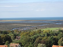
Its main feature is a 6.4 km (4.0 mi) spit of shingle and sand dunes, but the reserve also includes salt marshes, tidal mudflats and reclaimed farmland.
The area has a long history of human occupation; ruins of a medieval monastery and "Blakeney Chapel" (probably a domestic dwelling) are buried in the marshes.
The towns sheltered by the shingle spit were once important harbours, but land reclamation schemes starting in the 17th century resulted in the silting up of the river channels.
Up to 500 seals may gather at the end of the spit, and its sand and shingle hold a number of specialised invertebrates and plants, including the edible samphire, or "sea asparagus".
The many visitors who come to birdwatch, sail or for other outdoor recreations are important to the local economy, but the land-based activities jeopardize nesting birds and fragile habitats, especially the dunes.
[1] The main spit runs roughly west to east, and joins the mainland at Cley Beach before continuing onwards as a coastal ridge to Weybourne.
[6] Salt marshes have formed between the shingle curves and in front of the coasts sheltered by the spit,[5] and sand dunes have accumulated at the Point's western end.
[8][9] Norfolk Coast Path, an ancient long distance footpath, cuts across the south eastern corner of the reserve along the sea wall between the farmland and the salt marshes, and further west at Holme-next-the-Sea the trail joins Peddars Way.
[8][10] The tip of Blakeney Point can be reached by walking up the shingle spit from the car park at Cley Beach,[2] or by boats from the quay at Morston.
Both modern and Neanderthal people were present in the area between 100,000 and 10,000 years ago, before the last glaciation, and humans returned as the ice retreated northwards.
Blakeney sent ships to help Edward I's war efforts in 1301, and between the 14th and 16th centuries it was the only Norfolk port between King's Lynn and Great Yarmouth to have customs officials.
[24] Further enclosure in the mid-1820s aggravated the problem, and also allowed the shingle ridge at the beach to block the former tidal channel to the Salthouse marshes to the east of Cley.
[22] In the decades preceding World War I, this stretch of coast became famous for its wildfowling; locals were looking for food, but some more affluent visitors hunted to collect rare birds;[26] Norfolk's first barred warbler was shot on the point in 1884.
[27] In 1910, the owner of the Point, Augustus Cholmondeley Gough-Calthorpe, 6th Baron Calthorpe, leased the land to University College London (UCL), who also purchased the Old Lifeboat House at the end of the spit.
[28] In 1912, a public appeal initiated by Charles Rothschild and organised by UCL Professor Francis Wall Oliver and Dr Sidney Long enabled the purchase of Blakeney Point from the Calthorpe estate, and the land was then donated to the National Trust.
Bob Pinchen, Ted Eales and Ajay Tegala have all written books about their experiences on Blakeney Point as watcher, warden and ranger respectively.
[8] The Point juts into the sea on a north-facing coast, which means that migrant birds may be found in spring and autumn, sometimes in huge numbers when the weather conditions force them towards land.
[37][38] Numbers are relatively low in spring, but autumn can produce large "falls", such as the hundreds of European robins on 1 October 1951 or more than 400 common redstarts, on 18 September 1995.
Ornithologist and pioneering bird photographer Emma Turner started ringing common terns on the Point in 1909, and the use of this technique for migration studies has continued since.
A notable recovery was a Sandwich tern killed for food in Angola, and a Radde's warbler trapped for ringing in 1961 was only the second British record of this species at that time.
Grey seals breed in winter, between November and January; their young cannot swim until they have lost their first white coat, so they are restricted to dry land for their first three or four weeks, and can be viewed on the beach during this period.
[13] The corpses of 24 female or juvenile harbour seals were found in the Blakeney area between March 2009 and August 2010, each with spirally cut wounds consistent with the animal having been drawn through a ducted propeller.
[27] Records of mammals that are rare in the NNR area include red deer swimming in the haven, a hedgehog and a beached Sowerby's beaked whale.
These molluscs feed on the algae growing on the surface of the mud, and include the tiny Hydrobia, an important food for waders because of its abundance at densities of more than 130,000 m−2.
A 2005 survey at six North Norfolk coastal sites, including Blakeney, Cley and Morston found that 39 per cent of visitors gave birdwatching as the main purpose of their visit.
[11] This growth is thought to have been enhanced by the reclamation of the salt marshes along this coast in recent centuries, which removed a natural barrier to the movement of shingle.
[1] The spit is moving towards the mainland at about 1 m (1.1 yd) per year;[70] and several former raised islands or "eyes" have already disappeared, first covered by the advancing shingle, and then lost to the sea.
Sand was washed into the salt marshes, and the extreme tip of the point was breached, but as with other purely natural parts of the coast, like Scolt Head Island, little lasting damage was done.
It concluded that attempting to hold back the shingle or breaching the spit to create a new outlet for the Glaven would be expensive and probably ineffective, and doing nothing would be environmentally damaging.
[9] The ruins of Blakeney Chapel are now to the north of the river embankment, and essentially unprotected from coastal erosion, since the advancing shingle will no longer be swept away by the stream.


-
Salt marsh
-
Pasture
-
Sand dunes
-
Shingle
-
Car parks (circles) and roads
-
Marine


