Bloemfontein
Bloemfontein (/ˈbluːmfɒnteɪn/ BLOOM-fon-tayn;[4][5] Afrikaans: [ˈblumfɔntəin]), also known as Bloem, is the capital and the largest city of the Free State province in South Africa.
Situated at an elevation of 1,395 m (4,577 ft) above sea level, the city is home to 256,185 (as of 2011)[9] residents and forms part of the Mangaung Metropolitan Municipality which has a population of 747,431.
The city of Bloemfontein hosts the Supreme Court of Appeal, the Franklin Game Reserve,[11] Naval Hill, the Maselspoort Resort and the Sand du Plessis Theatre.
Though historically a !Orana and Barolong settlement, and then a Boer settlement, Bloemfontein was officially founded in 1846 as a fort by British Army major Henry Douglas Warden as a British outpost in the Transoranje region, at that stage occupied by various groups of peoples including !Orana (so-called "Korana" of the ǀHõaǁʼaes, ǀHũdiǁʼaes, Einiǁʼaes, and others), Cape Colony Trek Boers, Griqua (at that time known as "Baasters") and Barolong.
Warden initially chose the site primarily because of its proximity to the main route to Winburg, the spacious open country, and the absence of horse sickness.
The city constructed numerous public buildings that remain in use today, facilitated by the republic's governance and compensation from the British for the loss of the diamond-rich Griqua Land area.
On 13 March 1900, following the Battle of Paardeberg, the British captured the city and built a concentration camp nearby to house Boer women and children.
In 1913, the National Women's Monument was constructed on the outskirts of the city to commemorate all Boer civilians who died in concentration camps during the war.
[26] During the implementation of pass laws, the city saw major demonstrations that forced South African authorities to exempt women from them for nearly four decades.
[28] The National Party grew to govern South Africa in 1948 and implement the policy of racial segregation known as apartheid.
In Bloemfontein, residential segregation had begun in the 19th century with the passing of Ordinance 1 of 1860, which determined that no non-white, without written permission from the landlord (British government), had the right to occupy urban land in towns where local municipalities did not yet exist.
When the South African apartheid government passed the Group Areas Act of 1950, the Bloemfontein municipality put into effect changes in the racial set-up of the city.
The municipality demolished the Cape Stands residential area, which was occupied by the city's coloured population, and moved the residents to Heidedal.
However, due to Coloureds living in such proximity to black people, intermarriages across racial lines occurred, resulting in a partially mixed population in Heidedal and Mangaung.
Physical buffers such as the railway line and roads were put into place to separate black ethnic groups, the white and coloured population.
Bloemfontein is located in central South Africa on the southern edge of the Highveld at an elevation of 1,400 metres (4,600 ft), bordering on the semi-arid region of the Karoo.
Bloemfontein experiences a Cold Semi-arid climate (Köppen BSk), with hot summer days and cool, dry winters with frosty nights.
Rainfall usually arrives in the summer months, often in the form of dramatic but short-lived afternoon/evening thunderstorms that serve as a temporary relief from the heat.
The predominantly black suburbs are Rocklands, Phahameng, Phelindaba, Bloemanda, Bochabela, JB Mafora, and the most historic Batho, where the Maphikela House (where the African National Congress started) is situated.
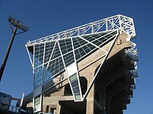
The venue was the hosting stadium of the 2010 FIFA World Cup South Africa matches played in Bloemfontein.
[36] The town has one of the most active soaring communities in South Africa and the world, using the New Tempe Airport, north of Bloemfontein.
[44] Most festival activities occur at the Loch Logan Waterfront, the largest shopping centre in central South Africa.
The Urth Garden Centre is a retail and wholesale nursery that is located on Kenneth Kaunda Road in Bloemfontein.
Like other major cities in South Africa, Bloemfontein's GDP growth has slowly decreased in recent years.
[clarification needed][57] The competition recognizes citizens of the City of Bloemfontein for contributions that go beyond their regular duties to enrich the Mangaung Metro.
Bloemfontein's national and regional roads are as follows: The N1, a major highway running roughly SW to NE from Cape Town to Johannesburg and Zimbabwe largely bypasses this city to the west.
[66] On 10 April 2012, Bloemfontein's historic Memorium cemetery was vandalized, with 35 tombstones toppled and obscene graffiti daubed on the walls of the adjoining Ohel.
The graffiti included images of money bags and diamonds, as well as of a crudely drawn Magen David, allegedly as part of an anti-Semitic act.
[67] There is also the old Phahameng cemetery, which dates back to the 1960s and was explicitly reserved for Africans during the apartheid era and has a Heroes Acre, where freedom fighters are laid to rest.
The Heide Heights cemetery in Heidedal was reserved for coloured people during the apartheid era, but all races could bury their dead after 1994.