Windhoek
It is located in central Namibia in the Khomas Highland plateau area, at around 1,700 m (5,600 ft) above sea level, almost exactly at the country's geographical centre.
It developed rapidly after Jonker Afrikaner, Captain of the Orlam, settled there in 1840 and built a stone church for his community.
Another theory suggests that Captain Jonker Afrikaner named Windhoek after the Winterhoek Mountains at Tulbagh in South Africa, where his ancestors had lived.
The first known mention of the name Windhoek was in a letter from Jonker Afrikaner to Joseph Tindall, dated 12 August 1844.
[4] He and his followers stayed near one of the main hot springs, located in the present-day Klein Windhoek suburb.
Two Rhenish missionaries, Carl Hugo Hahn and Franz Heinrich Kleinschmidt, started working there in late 1842.
In June 1885, a Swiss botanist found only jackals and starving guinea fowl amongst neglected fruit trees.
The borders of the German colony were determined in 1890 and Germany sent a protective corps, the Schutztruppe under Major Curt von François, to maintain order.
[9] Von François stationed his garrison at Windhoek, which was strategically situated as a buffer between the warring Nama and Herero peoples.
Colonial Windhoek was founded on 18 October 1890, when von François fixed the foundation stone of the fort, which is now known as the Alte Feste (Old Fortress).
Businesses were erected on Kaiser Street (presently Independence Avenue), and along the dominant mountain ridge over the city.
[14] In 1920, after the Treaty of Versailles, the territory was placed under a League of Nations Class C mandate and again administered by South Africa.
[8] The city introduced the world's first potable re-use plant in 1958, treating recycled sewage and sending it directly into the town's water supply.
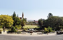
[20] Due to its relative size[21] Windhoek is, even more than many other national capital cities, the social, economic, and cultural centre of the country.
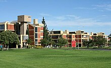
The University of Namibia is based in the city, as well as nearly every national enterprise, including the country's only theatre, all ministry head offices, and all major media and financial entities.
[25] Windhoek's three main access roads from Rehoboth, Gobabis, and Okahandja are paved, and are designed to be able to withstand the largest possible flood to be expected in fifty years.
Primarily, limitations such as runway length, noise, and air space congestion have kept Eros from developing into a larger airport.
Windhoek is connected by rail to: Expanding the town area has – apart from financial restrictions – proven to be challenging due to its geographical location.
In southern, eastern and western directions, Windhoek is surrounded by rocky, mountainous areas, which make land development costly.
Windhoek would become the third-largest city in the world by area,[citation needed] after Tianjin and Istanbul, although its population density is only 63 inhabitants per square kilometre.
[37] Windhoek's population currently[update] stands at over 325,858 (65% black; 18% other; 17% white), and is growing 4% annually in part due to informal settlements that have even higher growth rates of nearly 10% a year.
The Independent Patriots for Change (IPC), an opposition party formed in August 2020, obtained 14,028 votes and gained four seats.
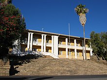
Two locations are part of the National Museum,[47] the Alte Feste (historical) showcases a range of colonial items such as wagons and domestic items, while the Owela Museum (scientific; named after Owela, a traditional game played with pebbles) contains displays of minerals, fossils and meteorites and gives an insight into traditional village life.
The men's national team has qualified for the Rugby World Cup on seven consecutive occasions, in 1999, 2003, 2007, 2011, 2015, 2019, and 2023, but is yet to win a game at the tournament.
[60] Farm Windhoek, located adjacent to the townlands and owned by the municipality, is a sports venue for hiking, running, and mountain biking.