Bloomingdale (Washington, D.C.)
Bloomingdale is a neighborhood in the Northwest quadrant of Washington, D.C., less than two miles (3 km) north of the United States Capitol building.
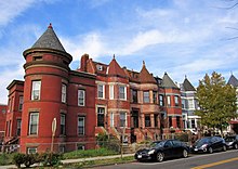
It is a primarily residential neighborhood, with a small commercial center near the intersection of Rhode Island Avenue and First Street NW featuring bars, restaurants, and food markets.
The neighborhoods bordering Bloomingdale are LeDroit Park to the west, Shaw to the southwest, Truxton Circle to the south, Eckington to the east, and Stronghold to the northeast.
Boundary Street, today Florida Avenue, was the dividing line between paved, planned streets (to the south), laid out in the original L'Enfant Plan, and rural country (to the north of Boundary), where landowners maintained orchards, large country estates and, later, a mixture of commercial properties.
As late as the 1870s, the land where Bloomingdale now sits was largely a collection of undeveloped private estates and farming properties, most prominently those of the Beales and of the Moores.
[7] Following Emily Truxton Beale's death in 1885, her heirs began to sell large tracts of the estate to developers.
[8] In 1891, the 45-acre (180,000 m2) Moore farm, north and west of the former Beale estate and representing some of the last undeveloped property in the area, was sold to private developers.
[citation needed] In the early 1900s, the remainder of the surrounding blocks had been built in a speculative nature by such developers as Harry Wardman, Francis Blundon, and S. H. Meyers in the following decade.
By 1909, the old estates had been sold and divided, the Tiber Creek had been buried, and the neighborhood street layout had been fully developed into its present form.
During this period of rapid change, new businesses have opened in the neighborhood, primarily restaurants, bars, and food markets.
The acre-and-a-quarter park, in the court bounded by First, U, V, and North Capitol streets NW, was previously the site of a warehouse built in 1910 and used as a telephone-switching station and cable yard for the Chesapeake & Potomac Telephone Company.
[18] Chesapeake & Potomac Telephone Company stopped using the property in 1974 and tried to sell it, but no one wanted to buy it,[18] largely because the only access was by way of an alley off of V Street NW.
[19] In 1976, a neighborhood organization, V Street Block Club, approached the Chesapeake & Potomac Telephone Company to donate the property.
[18] In December 1976, Hyman Construction Company learned about the issue, and it agreed to renovate the warehouse; Chesapeake & Potomac Telephone Company agreed to donate the land and the warehouse to a newly incorporated neighborhood organization, then called NUV-1, an acronym for each street that surrounds the property.