Blue Mountains (New South Wales)
The region borders on Sydney's main metropolitan area, its foothills starting about 50 kilometres (31 mi) west of centre of the state capital, close to Penrith.
[8] Several established towns are situated on its heights, including Katoomba, Blackheath, Mount Victoria, and Springwood.
[9] Once considered impassable by settlers, the 1813 expedition by Blaxland, Wentworth and Lawson opened up the interior to British settlement.
Since the early 2010s, the region's biodiversity and infrastructure has been severely affected by massive bushfires of unprecedented size and impact.
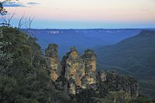
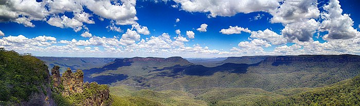
[14] A sandstone plateau dominated by a landscape of eucalyptus forests, the Blue Mountains are located at the top of a 470-million-year-old quartzite.
In the Permian period, a shallow sea covered the region, when rivers brought shales, siltstones and mudstones.
By about 1 million years ago during the Pliocene era, the Blue Mountains began to form, carving out deep valleys and steep cliffs, with an elevation of 3,900 feet.
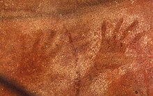
[15][16] The Blue Mountains have been inhabited for millennia by the Gundungurra people, now represented by the Gundungurra Tribal Council Aboriginal Corporation based in Katoomba, and, in the lower Blue Mountains, by the Darug people, now represented by the Darug Tribal Aboriginal Corporation.
[19][18] Gundungurra Tribal Council Aboriginal Corporation has a registered Native Title Claim since 1995 over their traditional lands, which include the Blue Mountains and surrounding areas.
[21]: 170 On the southern side of Queen Elizabeth Drive, at Wentworth Falls, a rocky knoll has a large number of grinding grooves created by rubbing stone implements on the rock to shape and sharpen them.
[24][25] Arthur Phillip, the first governor of New South Wales, first glimpsed the extent of the Blue Mountains from a ridge at the site of today's Oakhill College, Castle Hill.
He named them the Carmarthen Hills, "some forty to sixty miles distant..." and he reckoned that the ground was "most suitable for government stock".
The first documented use of the name Blue Mountains appears in Captain John Hunter's account of Phillip's 1789 expedition up the Hawkesbury River.
Describing the events of about 5 July, Hunter wrote: "We frequently, in some of the reaches which we passed through this day, saw very near us the hills, which we suppose as seen from Port Jackson, and called by the governor the Blue Mountains.
"[26] During the nineteenth century the name was commonly applied to the portion of the Great Dividing Range from about Goulburn in the south to the Hunter Valley in the north, but in time it came to be associated with a more limited area.
It is also believed that Matthew Everingham, 1795,[28] may have also been partly successful based on letters he wrote at the time which came to light in the late 1980s.
His descriptions and observations were generally accurate, and it is possible that he had crossed the mountains via the southern aspect at the Coxs River corridor, guided by the Aborigines.
In March of the same year, Wilson and Price ventured to the Camden area, and then continued further south until they encountered Thirlmere Lakes, finally almost reaching the present site of Goulburn.
Between 1798 and 1813, many people explored various parts of the mountains, from the Bilpin Ridge to the southern regions, today the site of the Kanangra-Boyd National Park.
In November 1813, Macquarie sent the surveyor George Evans on an expedition to confirm the apparent discoveries made by Blaxland and his party.
J.B. North ran a shale mine in the Jamison Valley in the 19th century,[21]: 243 and other operations were set up in several places.
The Blue Mountains is not known for particularly cold mornings compared to other areas on the Central Tablelands, such as Oberon, Bathurst and Orange.
However, the highest point in the broader region that was once considered to be the Blue Mountains is Mount Bindo, with an elevation 1,362 m (4,469 ft) AHD.
This latest fire burned for almost a month but was extinguished, mainly due to a change in the weather, without loss of human life or property.
[42] The area totals roughly 10,000 square kilometres (3,900 sq mi), including the Blue Mountains, Kanangra-Boyd, Wollemi, Gardens of Stone, Yengo, Nattai and Thirlmere Lakes National Parks, plus the Jenolan Caves Karst Conservation Reserve.
This site was chosen to be included on the World Heritage list because: "Criteria (ii) and (iv): Australia's eucalypt vegetation is worthy of recognition as of outstanding universal value, because of its adaptability and evolution in post-Gondwana isolation.
The site contains a wide and balanced representation of eucalypt habitats from wet and dry sclerophyll, mallee heathlands, as well as localised swamps, wetlands, and grassland.
It carries inherent dangers, yet for those with the appropriate skills or those looking to take a guided trip there are many great opportunities to experience a different view of the Blue Mountains.