Bolingbroke, Lincolnshire
[6] This suggests an Anglo-Saxon etymological origin, possibly "Bolingburh" or similar (burh of Bolla's people).
William de Roumare, Earl of Lincoln (born c. 1096), may have built Bolingbroke Castle in the 12th century as a motte and bailey castle with wet ditch to replace an earlier earthwork defence structure which overlooked the village on Dewy Hill.
In the early 13th century, a new castle was constructed at the present site by Ranulph de Blondeville, 4th Earl of Chester following his return in 1220 from the Fifth Crusade.
Later, John of Gaunt, son of Edward III, acquired the castle through his wife, Blanche of Lancaster.
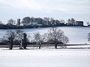
[7][8] The village sits in a broad valley of the Lincolnshire Wolds, between two streams, that rise in the surrounding hills.
To the north-east the road called Spilsby Hill climbs to a separate high point at Highfield Farm.
Sow Dale is the largest of the narrow valleys that cut through the Spilsby Sandstone ridge that forms the high plateau above the village.
[4][10] The high portions of the parish are composed of the Spilsby Sandstone,[11] which overlays here the deeper Kimmeridge and Ampthill mudstones.
[12][13] The parish boundary is complex, but can be summarised as surrounding the village, which is broadly central, and enclosing the rising ground in all directions.