Borders of India
India's Andaman and Nicobar Islands share a maritime border with Thailand, Myanmar, and Indonesia.
The state's Ministry of Home Affairs also recognizes a 106 kilometres (66 mi) land border with a seventh nation, Afghanistan, as part of its claim on the Kashmir region; however, this is disputed and the region bordering Afghanistan has been administered by Pakistan as part of Gilgit-Baltistan since 1947 (see Durand Line).
Maritime borders of India are the maritime boundary recognized by the United Nations Convention on the Law of the Sea entails boundaries of territorial waters, contiguous zones, and exclusive economic zones.
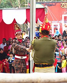
At the following border crossing sites the beating retreat flag ceremonies are jointly held by the military of both nations every day at 6 pm, which are open to the public as tourist attractions.
[15] These meetings include the playing of each country's national anthem and saluting of their respective flags, and ceremonial addresses by representative of both armies.
[14] On Indian side only Indian citizens are allowed to visit only 2 passes out of these several BPM passes/sites, Bum La Pass and Nathu La, only on Wednesdays, Thursdays, Saturdays, and Sundays, only after obtaining Inner Line Permit (ILP) one day in advance.
[18][19] The Benapole–Petrapole joint retreat ceremony results in lowering of national flags of India and Bangladesh.