Boreal forest of Canada
[2] The Canadian boreal region spans the landscape from the most easterly part of the province of Newfoundland and Labrador to the border between the far northern Yukon and Alaska.
), tamarack, and balsam fir) vary greatly in response to interactions among climate,[5] topography, soil, fire, pests, and perhaps other factors.
With its sheer vastness and forest cover, the boreal makes an important contribution to the rural and aboriginal economies of Canada, primarily through resource industries, recreation, hunting, fishing and eco-tourism.
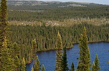
[7] The Canadian boreal forest is a very large bio-region that extends in length from the Yukon-Alaska border right across the country to Newfoundland and Labrador.
It is over 1,000 kilometres (620 mi) in width (north to south) separating the arctic tundra region from the various landscapes of southern Canada.
On the southwestern flank, the boreal forest extends into sub-alpine and lower elevation areas of northern British Columbia.
[8] However, across the Prairie Provinces, a band of aspen parkland marks a different kind of transition along the south-central flank from boreal forest to grassland.
[14][15] Since the melting of the great ice sheet, the boreal forest has been through many cycles of natural death through fire, insect outbreaks and disease, followed by regeneration.
Prior to European colonization of Canada and the application of modern firefighting equipment and techniques, the natural burn/regeneration cycle was less than 75 to 100 years, and it still is in many areas.
[11] Fire, on the other hand, recycles nutrients on location (except for some nitrogen), it removes accumulated organic matter and it stimulates reproduction of fire-dependent species.
[24] There are large areas of black spruce, a species which is tolerant of shallow soil, permafrost and waterlogged substrates, although as a consequence they have relatively low biological productivity.
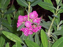
[26] Similarly, many of the understory shrubs are in the Ericaceae, a family known to tolerate acid, infertile and flooded habitats: examples include Labrador tea, sheep-laurel and blueberry.
Since nutrient levels are so low, overall, the productivity of forest trees is highly dependent on the rate at which mineral elements such as nitrogen and phosphorus are recycled by litterfall and decomposition.
An accurate summary is difficult, since most compendia on plants are organized by political, rather than ecological boundaries; one exception addresses the flora of the Hudson Bay Lowland,[28] but much of this area is not forested.
[32] The boreal forest wetlands provide wildlife habitat (particularly for migratory birds), they maintain water flow in rivers, and they store significant amounts of carbon that otherwise would be released to the atmosphere.
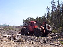
However, this is not considered deforestation by some, given that provincial laws are meant to ensure that areas harvested by the forest sector are replanted or regenerated naturally.
The Canadian boreal region contains the largest area of wetlands of any ecosystem of the world, serving as breeding ground for over 12 million waterbirds and millions of land birds, the latter including species as diverse as vultures, hawks, grouse, owls, hummingbirds, kingfishers, woodpeckers, and passerines (or perching birds, often referred to as songbirds).
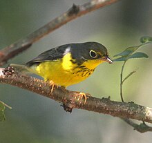
[38] The black-backed woodpecker shows a preference for burnt over forests, where it forages for insects burrowing in the dead trees that remain standing.
This moose-led transition in forest age class distribution and composition causes slower increases in net primary production with lower large herbivore populations.
It has been estimated that prior to European settlement, this renewal process occurred on average every 75 to 100 years, creating even-aged stands of forest.
[52] In the absence of fire, the accumulation of sphagnum peat on level upland sites would eventually oust coniferous vegetation and produce muskeg.
The negative effects of fire suppression are still under study, and not fully measured, but they need to be considered when making decisions about the future health of boreal forests.
A proposal was authored by Richard Rohmer in 1967 called Mid-Canada Development Corridor: A Concept and was discussed by officials and politicians but was never implemented.
The remaining three-quarters is either in parks, conservation areas, model forests or is considered non-timber-productive, generally defined as unsuitable for managed forestry or inaccessible.
[61] Most of Canada's conventional onshore oil and gas production, including the rapidly expanding oil sands production in Alberta, is located in the boreal region as is Canada's largest uranium producing zone in northern Saskatchewan and Quebec's largest hydroelectric generating facilities in the La Grande watershed.
[62] Since the early 1990s, a strong impetus has been created to focus on conserving Canada's boreal legacy and sustainably managing economic activity within the entire region.
[66] A report issued in 2011 by the Pew Environment Group described the Canadian boreal forest as the largest natural storage of freshwater in the world.
The canoe, the beaver pelt, the coureur des bois, the voyageurs, the Hudson's Bay Company and the North-West Mounted Police, the construction of Canada's transcontinental railways – all are symbols of Canadian history familiar to school children that are inextricably linked to the boreal forest.
The Group of Seven artists largely portrayed the boreal as natural, pure and unspoiled by human presence or activity and hence only partly a reflection of reality.
[69] The area also serves as the setting of Northern Tails, a 2025 Canadian children's educational puppet YouTube series about the local fauna.